Landpoint
  • Services
    • Land Surveying
    • Engineering Support
    • GIS & Mapping
    • Aerial Data Collection
    • 3D Modeling & Simulations
    • LiDAR – Laser Scanning
  • Markets
    • Oil & Gas
    • Energy
      • Wind Energy
      • Transmission
      • SOLAR LAND SURVEYING
    • Municipal & Federal
    • Industrial & Commercial
    • Residential
  • About Us
    • Company Information
      • Company Overview
      • Locations
      • Awards
      • Clients
    • Work at Landpoint
      • Job Openings
      • Benefits
      • FAQ’s
  • Projects
  • News / Articles
  • Contact Us
  • Menu

Archive for: 3D Modeling & Simulations

You are here: Home / West Company of Midland / Civil Engineering Services / 3D Modeling & Simulations
3d Laser Scanning Services, High Definition Scanning

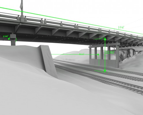
Murphy Viaduct HD Laser Scan

Wind Energy Development, Wind Energy Survey

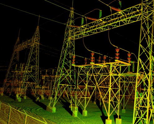
Power Substation 3D Laser Scan

Residential Land Survey, Property Survey, Boundary Survey

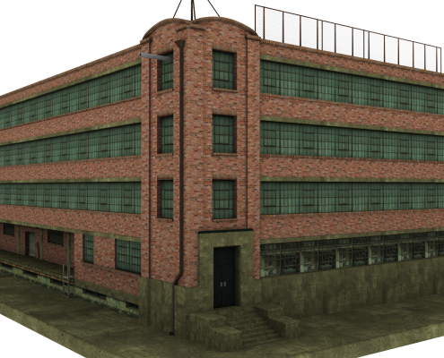
Ogilvie Hardware Renovation

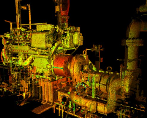
Compression Skid HD Laser Scan

Laser Scanning, 3D Modelling

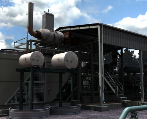
Gas Processing Facility

Pages

  • 3D Modeling & Simulations
  • Aerial Data Collection
  • Associations
  • Awards
  • Benefits
  • Bridge Simulation & Downloads
  • Browser Based Point Cloud Viewer
  • Civil Engineering Services
  • Clients
  • Company Overview
  • Compression Skid Downloads
  • Contact Us
  • Contact Us – King Surveyors
  • Copy of Drone Surveying for Pipeline Development
  • Drone / UAV Imagery Quote (Estimate)
  • Drone Services For Oil & Gas Pipelines
  • Drone Surveying for Pipeline Development
  • Drone Volume Calculation & Surveying Services
  • Drones (UAV’s) For Mining, Energy, Development
  • Drones for Utility Infrastructure
  • Drones Services For Oil & Gas Pipeline Inspections
  • Energy
  • Engineering Support Services
  • Environmental Services
  • Facility Scanning
  • FAQ
  • Gas Production Facility Simulation & Download
  • GIS & Mapping
  • High Resolution UAV Deliverables
  • Homepage
  • Industrial & Commercial
  • Job Openings
  • King Surveyors
  • King Surveyors Overview
  • Land Surveying
  • Land Surveying Jobs
  • Land Surveying Quote Request
  • Landpoint Awarded Oil & Gas Engineering Company of The Year
  • LiDAR – Laser Scanning
  • Locations
  • Markets
  • Municipal & Federal
  • News / Articles
  • Newsletter
  • Ogilvie Hardware Downloads
  • Oil & Gas
  • Oil & Gas Brochure
  • Oil & Gas Pipeline GIS Mapping Demo
  • Oil & Gas Production
  • Oil & Gas Project Management Demo
  • Pipeline and Facility Project Efficiency
  • Power Substation Downloads
  • Projects
  • Projects By Market
  • Request a Survey
  • Request For Quote
  • Residential
  • See More – Laser Scanning
  • See More – UAS
  • Services
  • Social Media Stream
  • SOLAR LAND SURVEYING
  • Standard UAV Deliverables
  • Subscription Removed
  • Terra Surveying Company, Inc.
  • test
  • Test dfgdfggfg
  • Thank You
  • Thank You – Drone Services Quote
  • Thank you for subscribing
  • Town and Country Surveyors
  • Transmission
  • TrueAtlas – Drone Data Explorer
  • UAV Browser Based Point Cloud Viewer
  • West Company of Midland
  • West Company Overview
  • Wind Energy

Categories

  • Article
  • News
  • Uncategorized

Archive

  • March 2022
  • February 2022
  • December 2021
  • November 2021
  • June 2021
  • May 2021
  • August 2020
  • July 2020
  • April 2020
  • March 2020
  • February 2020
  • January 2020
  • October 2019
  • September 2019
  • June 2019
  • May 2019
  • April 2019
  • March 2019
  • January 2019
  • November 2018
  • October 2018
  • September 2018
  • August 2018
  • May 2018
  • April 2018
  • December 2017
  • November 2017
  • October 2017
  • September 2017
  • August 2017
  • June 2017
  • May 2017
  • April 2017
  • February 2017
  • January 2017
  • November 2016
  • October 2016
  • August 2016
  • July 2016
  • May 2016
  • March 2016
  • February 2016
  • January 2016
  • November 2015
  • October 2015
  • September 2015
  • August 2015
  • July 2015
  • June 2015
  • May 2015
  • April 2015
  • March 2015
  • February 2015
  • January 2015
  • November 2014
  • October 2014
  • September 2014
  • August 2014
  • July 2014
  • June 2014
  • May 2014
  • April 2014
  • January 2014
  • December 2013
  • November 2013
  • October 2013
  • August 2013
  • June 2013
  • May 2013
  • April 2013
  • March 2013
  • January 2013
  • December 2012
  • November 2012
  • October 2012

We're here to help.

Call


Client Login

Latest Tweets

Services

Land Surveying
Engineering & Design
GIS & Mapping
Aerial Data Collection
3D Modeling & Simulations
LiDAR Scanning

Recent Articles

  • I Connect, We Connect; Life with MSMarch 30, 2022 - 1:08 PM
  • GIS Mapping ServicesWhat Should You Look for In a GIS Mapping Services Provider?March 1, 2022 - 10:05 AM
  • Underground Utility MappingWhich Utilities Need Underground Mapping?February 22, 2022 - 10:20 AM
  • SUE SurveyingThe Importance of SUE Surveying and Underground MappingFebruary 15, 2022 - 10:10 AM
© Copyright - 2019 Landpoint, LLC
  • Twitter
  • Facebook
  • Mail
  • Linkedin
  • Youtube
Scroll to top