Why Scalability is Key to Oil & Gas Surveying

land surveying projectsScalability is the ability to quickly adjust to changing conditions as they occur. Projects need to continue even when new information changes the nature of the operation and demands an increase in scope. When it comes to oil and gas projects, land surveyors must meet deadlines, manage change, and ensure the end result meets company needs and regulatory standards.

As oil and gas industry operations expand, land surveying scalability becomes a major challenge. Many surveying companies are small and unable to scale, while others may not be able to scale quickly enough to accommodate oil and gas companies’ needs. As a result, companies may experience much longer turnaround times. “Time is money,” and increased survey turnaround is inefficient and costly.

It is extremely beneficial when land surveying firms can efficiently and effectively provide accurate oil and gas field data to aid engineers in decision making and problem resolution. Land surveyors may be required to change course quickly. Regardless of conditions and obstacles, oil and gas surveying projects must meet deadlines and milestones. To do so, they need the team and the technology to be able to easily handle project changes as well as the ability to properly manage resources once they are in place.

Land Surveying Projects & Scalable Technologies

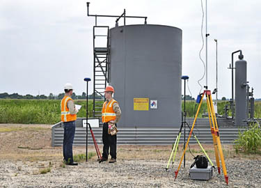
Most oil and gas surveying projects are multi-phased, from field data collection, to surveyors review, to client deliverable distribution. Oil and gas surveys tend to become more complex as the project progresses. An original survey may turn into re-rotes, moves, and overall scope increases, requiring more resources and in many cases additional skill sets. The survey firm should have the capacity and resources to be able to add additional crews and equipment as needed.

Having access to some of the latest surveying technologies enhances scalability. For example, the best GIS uses significantly more data and keeps all of the information in the cloud. Data is made available through smartphones and tablets, enhancing communication between teams and keeping everyone in the loop. When information is kept in a central location and made easily available to those in the field, it means that no matter how many new teams are added, everyone will still be on the same page.

Some important methods, programs, and project management features indicating a surveying company is focused on continued scalability are:

  • Advanced GNSS
  • 3D scanning applications
  • Mobility / mobile devices
  • A real-time, in-house project management system
  • Knowledge of oil and gas companies’ multiple land leases and operations
  • A large pool of readily-available on-call survey teams
  • A reputation for updating and incorporating the latest technologies
  • Professionals that are knowledgeable of the most current land survey technologies

The Benefits of Scalable Oil and Gas Surveying

Ultimately, partnering with a firm that can easily scale helps your oil and gas project with three critical elements:

  1. Speed – By being able to add additional resources as soon as they are needed, a scalable land surveying company can vastly reduce the time needed to complete a project.
  2. Accuracy – A land surveying company needs to have a broad skill set and experience in a number of different oil and gas surveying related disciplines in order to take on the additional tasks that may come up in a project. If they do not have these things, they may attempt to take on tasks with mixed results.
  3. Efficiency – The more a project expands and changes, the more necessary it is that the surveying company be able to communicate with other teams and share information.

It is better for an oil and gas company to pick a land surveying company that can scale right from the start, instead of having to change midway when it becomes clear that the current surveying company cant. For more information, take a look at our oil and gas brochure.

Landpoint Acquires Two Other Land Surveying Companies, Awarded “Deal of the Year”

Oil and Gas ProjectsLandpoint scored big at the annual D CEO/ACG Mergers & Acquisitions Awards event held May 6 in Dallas, winning the award for “Deal of the Year” in its category.  The award was based on the Landpoint’s recent acquisition of two other land surveying companies: West Company of Midland, LLC. in Midland, Texas and the Fort Collins, Colorado based King Surveyors, LLC., last year.

The company’s deals topped competitors in the category of similar transactions, worth up to $50 million. The company now has more than 220 employees and nine office locations in five states – including its new Midland, Texas regional office with a primary focus on oil & natural gas infrastructure development.

“We are honored to have caught the attention of D CEO and ACG’s Mergers & Acquisitions Awards panel,” said company Vice President Chad Souter. “We were very confident in our initial strategy and it’s exciting to receive recognition from leaders in the M&A industry.”

Landpoint’s strategy included diversifying its client base and geographical exposure through acquisitions that paralleled the organic growth strategy of the company. Landpoint has become a platform for future acquisitions and has automated many processes for integration and development plans. The combined land surveying companies of Landpoint, King Surveyors, and West Company of Midland now hold a significant market share for top production and midstream companies throughout the Eagle Ford and Permian Basin, as well as the Niobrara and Haynesville shale plays.

The awards, presented by D CEO and the Association for Corporate Growth, highlighted four different categories: small, midsize, large and mega deals, as well as a handful of dealmakers for businesses in the North Texas region. The North Texas economy and growth of mergers and acquisitions has come back strong in recent years. The awards focused on 38 deals with a total of $45.7 billion for 2013.

Pre-Construction Planning Process: How Land Surveying Services Help

ID-100208177A construction survey typically consists of determining current site conditions for future above-ground and in-ground infrastructure. Land surveyors stake elevations for footings, collect topographic data for mapping existing drainage courses, invert elevations and diameters of pipe and manholes perform a number of other services. Land surveying services are used to establish the accurate location of proposed structures, accesses, pipelines, buildings, and other improvements.

Most land surveying services are provided by local companies or companies with local offices. They typically have some prior knowledge of the area to be surveyed, including its history, soil& water conditions, sensitive areas, habitats and protected species. This not only reduces the time to get to the designated site, but also provides the client valuable area insight upfront, from which decisions may be made and plans designed.

Land surveying services can include due diligence as well. Land survey teams may inspect buildings for hazardous materials such as asbestos, lead, and PCBs, which must be addressed prior to demolition, new construction or exploratory operations. Land surveyors may also discover other issues such as buried fuel tanks or ground water contaminants.

How Land Surveying Services Help With Pre-Construction Project Planning

A surveying firm adds more value to the pre-construction planning stages of any project. In addition to site analysis, boundary & topographic surveys, maps, and plats, they also:

  • Help mitigate the risk of potential future regulatory enforcement actions
  • Minimize or eliminate costly delays in project schedules
  • Maximize project startup efficiencies through comprehensive regulatory planning
  • Provide data which helps define project scope and aids strategic pre-construction planning
3D Scanning for Retrofits

Retrofitting involves modifying existing structures or equipment to reinforce and add structural life to it. Many existing buildings, overpasses, bridges, and towers are being retrofitted to withstand potential seismic shaking and shocks.

Surveying teams collect data which is used to construct a 3D model of the existing environmental features, structures, and objects. 3D scanning is ideal for analyzing, planning, and designing retrofit projects. The surveying team collects its data points in the field and creates a digital model that depicts height, width, and depth.

3D maps and point clouds show elements and measurements of buildings, utilities, construction and structural objects such as pipe, cable, and plumbing. This is very helpful when an existing building or structure (such as a bridge) is scheduled for retrofitting. Engineering departments find these deliverables invaluable when working on retrofit projects.

Establishing Survey Standards

For any given project there may be more than one surveying company involved. One surveying firm may well establish basic standards in the pre-planning phase for other surveying teams to follow. A responsible and reputable surveying company may set the standard for work production and quality, safety, schedule, and deliverables. This indirect competition and expectation tends to escalate project progress. Additionally, established standards clarify expectations which contribute to enhanced quality control.

GIS and BIM (Building Information Modeling) Software Tools

Land and air surveys provide data to build models and 3D mapping. GIS (Geographic Information System) software aids in large scale planning. Data collected may be analyzed and processed. GIS applications may be used to assist project pre-planning in areas of:

  • Resource management
  • Utility management
  • Infrastructure management
  • Environmental impact studies and land management
  • Leased land, land use, zoning, and boundaries
  • Plats and development
  • Legal descriptions and measurements
  • Market and statistical analyses

BIM (Building Information Modeling) is another software decision making tool that assists in planning physical features and infrastructure such as water, gas, communication, power lines, buildings, and roads. BIM expands 3D modeling. It includes concepts of time and cost in addition to height, width, and depth. Component quantities and spatial relationships are integrated into the process. BIM extends through the project lifecycle, far beyond the pre-construction planning process. The BIM program supports:

  • Construction management
  • Project management
  • Facilities management
  • Cost management

For more information on GIS, BIM, and pre-construction planning offerings, please take a look at our brochure.

Image By : Stockimages

Oil and Gas Projects: Finding a Safety-Focused Partner

pipeline land surveyingIn accordance with OSHA (Occupational Safety and Health Association), every worker has a right to a safe work environment. This is especially important for those in the oil and gas industry for the company as well as for their consultants and partners.

Oil and gas project safety has to be everyone’s priority regardless of job assignment, office or field. Vehicle accidents, explosions, fires, chemical exposures, confined space hazards, or employees caught in equipment may occur on rigs, in wells, or along pipelines. And, hazards that cause people to fall, trip or slip are a threat in any workplace environment.

Safety on Oil and Gas Projects: The Most Common Violations

OSHA’s General Industry Standards (29 CFR 1910), OSHA’s Construction Standards (29 CFR 1926), and General Duty Clause of the Occupational Safety and Health (OSH) Act were enacted to protect worker health and safety in the oil and gas industry.

According to OSHA oil and gas surveys, the five most-cited violations are:

  1. Hazard Communication (HazCOM) – Negligence of OSHA requirements to provide material safety data sheets (MSDS) for all hazardous materials and chemicals, posted notifications of hazards and chemicals present, or employee training (regular safety meetings).
  2. Permitted confined spaces – Safety violations occurring in spaces with limited egress and those over 4-feet deep, including manholes, mineshafts, airshafts, wells, crawl spaces, etc.
  3. General Duty Clause (Section of the OSHA Act) – Failure of the employer to comply with OSHA standards or provide a workplace/jobsite free from recognized safety hazards that might cause death or serious physical harm to employees or employee(s) failure to comply with OSHA standards through acts and actions (including drug and alcohol abuses).
  4. PPE (Personal Protective Equipment) – Failure to comply with the OSHA requirement to provide and wear gloves, coveralls, respirators, protective head gear, safety reflective vests, ear, eye, and face protections.
  5. Wiring, Components, and Equipment – Failure to control gases under pressure that might ignite, cutting and welding near flammable or explosive materials, or poorly maintained electrical wiring or equipment.

Setting Safety Standards on Oil and Gas Projects

Studies indicate that employees who are injured are typically:

  • Male
  • Age 25-34
  • Employed less than one year
  • Struck by an object (related to parts or materials)
  • Experienced a strain or sprain to their arms, wrist, hands, or fingers
  • Off work for 31 or more days

It is important for the company to set high standards for safety early on in a project. This pertains to the employer, workplace/jobsite, employees and their behaviors that might indirectly create a hazardous environment (negligence, intoxication, addiction, anger/violence, etc.).

Explosions, oil fires, chemical spills, collapses, cave-ins, and confined space Oxygen deprivation require employee training in proper mitigation and PPE use, emergency response, site securing, and recovery operations. HazCOM enforces employees’ rights to know potential hazards, how to avoid them, and what to do in the event one occurs. Teamwork and support are equally important.

Oil and Gas Project Safety Concerns: Selecting Partners

Responsibility for safety extends to companies the oil and gas company chooses to partner with. Criteria to determine if a firm (survey, engineering, construction team) is credible, responsible, and safe include:

  • Flexibility – Is the partner willing to accept the oil and gas company’s established safety guidelines?
  • Experience/ Accreditation – Does the partner have knowledge, experience, accreditation, and a clean workplace accident record? (Generally, experienced and accredited firms tend to be “safer”).
  • Ability To Identify Potential Dangers – Is the partner cognizant of conditions that could be hazardous? (Survey Partners using GIS, for example, may identify and mitigate potential safety concerns early in the project).

The partner may additionally be evaluated based on the following desirable qualifications:

  • ISNetworld, PEC/Premier, and PICS compliant in all areas of operation
  • Demonstrated enforcement of NCMS DOT drug and alcohol compliance for personnel
  • Active personnel health and safety program including regular safety meetings

On the job site, safety and accurate end results are of paramount importance. Landpoint is 100% ISNetworld, PEC/Premier, and PICS compliant in all areas and enforces NCMS DOT drug and alcohol standards. We invite you to contact us to learn more about what we can do for your oil and gas project.

Image By : SweetCrisis