Need an Alta Land Survey? Get It Made With HD Scanners

land-survey1
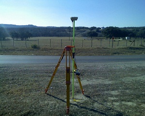
To assist our clients in designing and executing projects in the most efficient way possible, Landpoint relies on the very latest high definition scanning technologies when creating an ALTA land survey. These innovative technologies help our project managers and outside engineers and architects visualize all the components of any site or facility, and it allows us to make better decisions based on the building conditions.

We utilize high definition scanning to meet a variety of professional land surveying needs, including pre-project scanning, the creation of traditional 2D drawings, change detection, catastrophic event mapping and accident reconstruction, and it is particularly helpful in completing scans for ALTA certification.

Using high definition laser scanning, we can complete a field survey for ALTA certification in just one day. In less time than ever before, we can produce fully interactive 3D models, maintenance materials and detailed animations, including complete fly-trough’s alongside the traditional materials expected from an ALTA land survey.

As a professional land surveying firm, high-def laser scanning benefits our clients in many ways:

Reduced Cost

Using the technology significantly reduces the amount of field visits our team has to make to collect data. This cuts the overall cost to you, resulting in more cost-efficient projects.

Future Planning

The data we collect through high definition laser scanning is not just valuable for your current projects, but can be saved and used for your future projects as well. The accurate, detailed data makes future planning far easier.

Quality Assurance

The data collected using high definition scanning is highly accurate. This ensures that your project will be based on the most solid knowledge of your site.

Speed

High definition laser scanning enables us to collect accurate data more quickly than ever before. Instead of taking weeks or months to complete your project, we can have it finished in just days.

This technology gives project managers insight into their locations that was never available before. The result is better project planning, easier decision making and overall more successful projects.

To learn more about getting an ALTA land survey and how HD laser scanning can benefit you, contact us today!

Image By – survcentex

3-D As-Built Survey in Oil and Gas Development

oil-gas-as-builtUsing the latest 3D high-definition laser scanning equipment and high end 3d modeling software, Landpoint is able to create as-built intelligent models with incredible accuracy. This technology is particularly useful for oil and gas development.

A New Type of As-Built Plan

In 2011, Landpoint created an as-built model of a portion of a gas processing facility in Haughton, Louisiana. We used this innovative technology to create a model that is within ¼ inch accuracy in just ¼ day.  While using only four scanning positions we were able to capture a full 360° detailed view of the facility towers, and the entire project took only 14 days to complete. Before the development of 3D laser scanning, a project of this scope would have taken much longer and resulted in far less accurate data.

With this detailed model, multiple departments can work together to plan future expansions, renovations, or assess the status of current assets already on the ground. This collaboration results in better planned oil and gas development projects and faster results.

Why Getting a 3D As-Built Survey Makes Sense

3D Laser Scanning data and BIM go hand in hand. BIM, or Building Information Modeling, is the technology of the future being used on today’s complex construction projects. It imbeds relevant information into the data of the model such as materials, part sizes, flow rates, tensile strengths, maintenance schedules, life spans, part locations and many more. Scanning is a huge benefit to the BIM process serving as the foundation for renovation, addition or improvement projects or as an effective means to compare As-Built plans to the design model during construction. This significantly reduces costly RFI’s (request for information), mistakes and rework. This ultimately cuts down on the overall time and money spent on your oil and gas development projects.

To learn more about how Landpoint and 3D high-definition laser scanning can bring success to your oil and gas development project, contact us today.

GIS Mapping has Revolutionized Pipeline Surveying

pipeline surveying
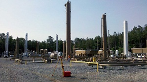
With the ability to manage, analyze, edit, and display data in a multitude of ways, it’s no wonder Geographic Information Systems (GIS) have become an integral part of pipeline surveying and development. Our GIS techniques incorporate first class technology and professional know-how to provide our clients with the very latest pipeline data displayed in real-time at each stage of planning, development, and construction.

What is GIS Used For During Pipeline Surveying?

From the original survey shots for easements and centerlines, to the planned and proposed phases, and all the way up to the finished As-built pipeline, GIS provides the methods to track your data every step of the way. Even multiple re-routes can be kept fully up to date and available to you when time and decision making are of the highest importance. Field crew members, Project Managers, Construction teams, Regulatory Personnel and everyone in between can utilize our GIS services to conduct their tasks more efficiently than ever before.

Pipeline attributes can be very extensive and difficult to organize, but an efficient GIS eliminates this issue. Pipeline size, asset product, grade, wall thickness, length and much more are all made easily available to you both in the office and in the field through our Mobile GIS technology. Pipelines can also be classified and displayed according to their type: Trunkline, Gathering, Lateral, etc. for a clear, concise picture of product flow from the well site to the final destination. From the start of construction to the final regulatory review, our GIS services are aimed to facilitate effectiveness in each and every task for a successful pipeline surveying project.

With an efficient GIS in place, all pipeline data can be housed in a single, well organized location and utilized by multiple positions, departments, and industries each with their own focus and tasks. To learn more on how Landpoint, Inc. GIS mapping can bring success to your pipeline surveying project, contact us today.

Image By: Wessex Archaeology

Solar Energy Plant Development Using GIS

solar energy plant GIS is a powerful tool that makes it easy to collect, store, manipulate, analyze and display accurate information in a geographically organized manner. Using this geographically referenced data, clients can visualize trends, patterns and relationships in the data so they compare the suitability of multiple locations for solar energy plant development.

Using GIS for Renewable Energy Projects

GIS maps begin as simple geographic maps, but they become so much more. We can add an infinite number of datasets to the base map, creating multiple layers of information. Then, we make the maps interactive so you can easily look into specific information for your project, while not losing track of the big picture. GIS plays a critical role in placing solar energy plant projects by allowing planning commissions, policymakers and others to decide which locations are best for developing solar energy with the least amount of impact on the population.

Applications of GIS Data for Solar Projects

This tool also reduces the environmental and social impact of solar energy plant projects. By displaying spatial variables in an easy-to-understand manner a GIS map can help project managers avoid major project complications. GIS can make it more apparent when there are patterns in the data and highlight details that may have been overlooked when seen in a less coordinated fashion.

For example, with the ability to view multiple datasets in just one GIS map, project planners can compare historical ambient temperatures and solar radiation levels in various locations. This allows them to select optimal locations for a solar energy plant’s location.

Through the map, users can calculate the solar radiation available on building rooftops, build digital elevation models and analyze the effect changes in orientation, elevation, and topographical features. Easy-to-use web-based GIS maps take this data and present the logistics of solar energy investment to everyone who needs access. With these web-maps companies can display and share large amounts of data across departments or even between organizations so everyone has a chance to use the data to come up with the best solution.

The Importance of GIS for Solar Projects

This simple yet powerful tool has an intuitive interface that changes the way we view solar energy and opens the door for larger, more widespread projects. Using GIS for renewable energy projects improves the way we deliver and produce energy and supports the development of cleaner, smarter and more eco-friendly methods of energy production. To learn more about how Landpoint and GIS Mapping can bring success to your energy project, contact us today.

Image By: pgegreenenergy