GIS Mapping has Revolutionized Pipeline Surveying
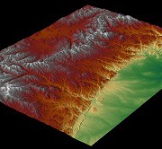
 With the ability to manage, analyze, edit, and display data in a multitude of ways, it’s no wonder Geographic Information Systems (GIS) have become an integral part of pipeline surveying and development. Our GIS techniques incorporate first class technology and professional know-how to provide our clients with the very latest pipeline data displayed in real-time at each stage of planning, development, and construction.
What is GIS Used For During Pipeline Surveying?
From the original survey shots for easements and centerlines, to the planned and proposed phases, and all the way up to the finished As-built pipeline, GIS provides the methods to track your data every step of the way. Even multiple re-routes can be kept fully up to date and available to you when time and decision making are of the highest importance. Field crew members, Project Managers, Construction teams, Regulatory Personnel and everyone in between can utilize our GIS services to conduct their tasks more efficiently than ever before.
Pipeline attributes can be very extensive and difficult to organize, but an efficient GIS eliminates this issue. Pipeline size, asset product, grade, wall thickness, length and much more are all made easily available to you both in the office and in the field through our Mobile GIS technology. Pipelines can also be classified and displayed according to their type: Trunkline, Gathering, Lateral, etc. for a clear, concise picture of product flow from the well site to the final destination. From the start of construction to the final regulatory review, our GIS services are aimed to facilitate effectiveness in each and every task for a successful pipeline surveying project.
With an efficient GIS in place, all pipeline data can be housed in a single, well organized location and utilized by multiple positions, departments, and industries each with their own focus and tasks. To learn more on how Landpoint, Inc. GIS mapping can bring success to your pipeline surveying project, contact us today.
Image By: Wessex Archaeology

