Posts

Why Planning with GIS is Critical for Pipeline Routing Projects

Pipeline Surveying
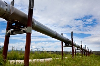
While pipelines do provide a cost-effective method of transporting oil and gas across long distances, it is still crucial for companies to save on pipeline development costs when they can. Pipeline development represents one of the most significant capital investments oil and gas companies will make, so everything they can do to cut costs helps.

One of the key ways oil and gas companies can cut costs on their pipeline development projects is by using GIS mapping tools for pipeline surveying. Of the many factors that drive high expenses for pipeline routing projects, most of them, including things like diameter, distance, and operating pressure, represent fixed costs that companies really have no control over.

On the other hand, companies can control which terrain they choose to route their pipelines through. This means that pipeline routing is one of the few opportunities that oil and gas companies have to easily cut their pipeline development costs, and GIS is one of the best ways to take advantage of that opportunity.

GIS: A Solution for a New Generation of Pipeline Surveying

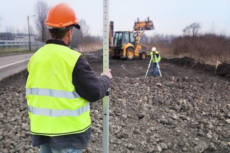
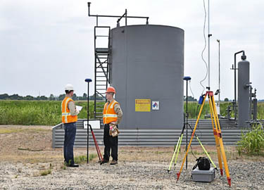
In the past, oil and gas companies could build their pipelines just about anywhere. Now, as pipeline right-of-ways grow more and more congested, these companies have to be very selective when picking a route in order to avoid both natural obstacles and existing pipelines.

Fortunately, with GIS, oil and gas companies have a new technology that can help them better address this new challenge. GIS helps provide a far more accurate look at a piece of land than ordinary topographical maps could ever provide, offering a clear and complete representation of the spatial relationships around a piece of terrain. As a result, oil and gas companies can get a pipeline route map that helps them make more cost effective decision.

Factors That Define Optimal Pipeline Routing

In pipeline surveying, obstacles like wetland crossings and rough terrain create problems for companies. The pipeline development will have to stop whatever they are doing to find a way to make the pipeline go through, around, or beneath the obstacle. Having to change the pipeline route like this is a waste of time and money, which is why it’s always good to use GIS and just avoid the obstacles in the first place.

It’s also important to recognize that GIS can help you in a variety of other ways as well. When oil and gas companies develop pipelines, they have to account for issues such as how the new pipeline will affect the community. This is important because it helps companies consider things like how the settlements would be affected in the event of oil leakage, and how much the company would have to set aside for compensation payments to existing land owners.

In addition, oil and gas companies have to consider the environmental impact of their project before they can successfully pitch the project to the appropriate regulatory boards. GIS helps planners understand the overall impact of the project, and how to alter the pipeline routing to minimize the damage to vegetation and avoid protected areas like wetlands altogether.

Final Thoughts

In pipeline surveying, what you can’t see definitely can hurt you. Failing to account for poor terrain and other obstacles can delay your project, which costs money. Failing to account for how your pipeline will affect people and the environment can also be very costly, both in terms of financial losses and damage to reputation. Having as much visibility over your pipeline route as possible is key, and GIS can provide that visibility for you.

Ultimately, utilizing GIS services will help you save money and ensure a more efficient and cost effective pipeline route map.

Unmanned Aerial Vehicle

How Cloud Computing is Revolutionizing Oil and Gas Projects

cloud computingCost cutting and improved efficiency are central to oil and gas companies. Changes in the industry, new regulations, and increased competition have companies looking at technology differently than they did even five years ago. In particular, cloud computing is revolutionizing the oil and gas industry, particularly in areas of oil and gas surveying and project management.

Cloud computing platforms can be somewhat invisible. Because they are so simple to use and make previously complicated tasks easy, it is entirely possible that the user may not realize just how much this technology is impacting their business.

The Value of Cloud Computing to the Oil and Gas Industry

Cloud computing, in general terms, is the ability to simultaneously distribute information over a computer communication network to many users. The flip side to this is the ability to access and retrievethe vast amounts of stored dataregardless of time and location.

Cloud computing is extremely popular in industry and business for the same reasons any innovation or technology is popular: improved efficiency and cost effectiveness.

This is especially useful for the oil and gas industry, which has to handle large amounts of data as well as manage multiple, often remote teams. With any oil and gas project there are a lot of moving parts, and cloud computing can be used to make these parts work more seamlessly with one another. Important data and documents can be easily accessed by those partners who are cleared to view them. Since information is available onany internet capable device, data can be uploaded from a project site and made instantly available back at regional centers or corporate headquarters.

Land Surveying and GIS Mapping via the Cloud

Quality control, connectivity, and real-time survey and drilling data are enhanced through cloud computing. Mobile devices are already used by oil land surveyors to collect data and upload it to servers. Seismic crews use wireless recording stations to ensure quality control.

Data can be collected from the field and immediately uploaded. Land surveyors collect data and cartographers in an office in the next state can interpret and map it for immediate uploading and distribution. Stored map information may be integrated into other internal systems, or used on-site by the project manager and crews.

Oil and Gas Data Management: Now in the Cloud

Project managers utilize cloud technology to query and view cross-project and multiple task data files. Historical, geological, and drilling operations data relevant to the project they are working on, can be accessed by simply logging into the cloud repository.

Using cloud technology for Oil and gas data management also makes it easy for the project manager to share pertinent information with all project stakeholders. Additionally, data can be easily cross analyzed and interpreted, leading to decisions being made and conveyed faster, thus reducing adverse impacts to the community, company, and environment. This efficiency also translates into minimization of costs associated with delays, slowdowns, catastrophes, or other unplanned interruptions.

Using cloud data also provides project managers with additional information to effectively determine critical milestones, create achievable schedules, and generate more complete reports and more informed budgets.

The cloud provides a continuous and secure flow of information from a variety of cross-disciplined experts. When oil and gas companies implement a cloud computing platform, they will see much more reliable service results while saving money at the same time.

If you are looking to use cloud technology to cut costs and increase efficiency, then try our Oil & Gas Data Management Demo for free and see what a difference it can make.

Image By : SweetCrisis

How Modern Surveying Means Less Time Spent On Site

Oil and Gas ProjectsTechnological advances in land surveying equipment and methods are transforming the industry by streamlining the surveying process and reducing the number of resources needed to complete projects, especially on the ground. Traditionally, field data collection has been a very hands-on process, whereby surveyors expend considerable time and resources on-site to manually map out areas and provide a basic blueprint for clients.

Now, armed with sophisticated technologies, like 3D scanning and modeling, modern GPS surveying tools, GIS mapping, and high-tech data collectors, some land surveyors are transforming the industry. The results – the field data collection process is significantly shortened and clients receive more detailed and accurate results, all the while with fewer resources, especially on site. Ultimately, these outcomes improve clients’ bottom line, expedite the survey life cycle and minimize the risk of costly errors and need for rework.

Which technologies should companies be looking for when it comes to field data collection?

GNSS Surveying. The Global Navigation Satellite System (GNSS) is the foundation for modern surveying. GNSS pulls data not only from the American global positioning service (GPS) but from other entities as well, creating even more accurate results. Historically, surveyors physically canvassed areas to plot coordinates and demarcate boundaries; everything was done manually and on-site. Using GNSS surveying equipment, surveyors can access geographic data points gathered by a network of satellites that rotate around the earth and collect positioning data on an ongoing basis. This switch has dramatically increased surveyors’ productivity and made their surveys much more accurate

High-Tech Data Collectors. In the past, collecting data was one of the most time consuming parts of the surveying process. While manually canvassing an area, surveyors would physically enter their data and sketches, often using a pencil and paper. High-tech field data collectors enable automatic entry of thousands of points of data into an online system. This process has revolutionized the surveying field by significantly reducing the number of people and the time it takes to complete a survey. In addition, automating the field data collection process minimizes errors caused by human entry.

GIS Mapping. Geographic information systems (GIS) are systems that store mapping information and attributes in digital form so that it can be easily accessed and analyzed. For surveyors, using GIS mapping is a powerful tool, because it helps provide a simple, visual context for what would otherwise be complex, spatial datasets. Further, GIS mapping allows data to be easily manipulated using a multitude of variables that can be layered over one another. GIS mapping information is stored in the cloud, so data can be accessed in real-time from the convenience of any device connected to the internet. This feature helps improve communications between surveyors and their clients and gives clients the ability to effectively manage projects on a daily basis from remote locations.

3D Scanning and Modeling.  3D scanning and modeling or “high definition scanning,” as it is sometimes called, is a process that uses advanced lasers to map an area in extremely high detail. Essentially, 3D scanning technologies capture image data points at an incredibly rapid pace to create a precise, almost life-like visual of the project area. Most importantly, 3D scanning technologies precisely map out coordinates to millimeter accuracy, thereby significantly improving the reliability of the survey itself. In turn, clients can make more informed decisions about their projects.

Selecting a surveyor with experience using these technologies can significantly improve a project’s bottom line, especially for Oil & Gas, Clean Energy and other companies, for whom surveying is an integral part of their business. To see how cutting-edge surveying technologies and techniques can help you save time and cut costs, get a no obligation quote today.

Three Land Surveying Services That Can Speed up Pipeline Construction Projects

land-surveying-pipelineWhen it comes to the oil and gas industry, it is important that pipeline infrastructure projects are well organized to keep the various subcontracting and supervising entities up to speed. There can be significant consequences if a single pipe is placed in an incorrect location because of a lapse in communication or outdated plats. If an existing pipe were to be punctured because of ill positioning, there could be severe regulatory penalties as well as immediate health and safety hazards. A knowledgeable land surveying company has many tools at their disposal to ensure that intended work areas and techniques are compatible. The primary differentiating tool that Landpoint offers is the project management site to keep all of the subcontracting and supervising entities up to date with shared plats and GIS mapping solutions that are updated in real-time as the licensed surveyors release new information. Landpoint can combine all of the traditional services, such as construction staking and layout or as-builts, and with this proprietary tool to give your company the value added services required for modern pipeline projects.

Construction Staking and Layout

Our qualified land surveyors have a unique understanding of how the pipeline construction industry operates. Once the land group has completed the project design land surveying team can then map out the dedicated easement of the project area and the location of the pipelines’ proposed centerline. The data is then immediately available for review and re-routes.

As-Built Surveying

One of the most important services that all pipeline projects should consider is live construction as-builts.  These surveys can be completed throughout the pipeline construction phase and can be platted as a profile or overview map to show where recently-completed projects lie on a construction site. This process makes sure the construction companies are properly building the pipeline as it has been approved.

GIS Mapping

Land surveying companies should provide GIS mapping to create a database of wells, trunk lines, laterals, and other assets in order to facilitate the organization of the project. Construction workers can use this information to better understand how the site elements of a major construction project fit together. During the planning stages, GIS helps speed up project timelines by showing regulatory agencies or construction crews exactly what designers want; GIS maps are much more intuitive than a flat paper plan, especially with complex design elements. Additionally, the GIS system can link pipelines and other assets to official documentation for ease of access on any device.

Landpoint’s experienced team can help you choose the services that will get your pipeline project started and keep it moving smoothly. Contact us today to learn more about construction as-builts, staking, and the services we offer.

Image By: puttsk

GIS Consulting Services for Intelligent Transportation Systems

GIS mapping, GIS consulting GIS consulting services provide critical assistance for planning, maintaining, evaluating and managing the infrastructure of transportation systems around the globe. Intelligent transportation systems are based on the results of GIS consulting, enabling decision makers to prioritize their work and make the best choices. With GIS mapping technology, you can build rich, dynamic and detailed mapping applications that will guide your project from start to finish.

How GIS Consulting Services Help At Every Stage of Development

Transportation planning projects stem from a lifecycle that starts with the planning stage and includes design, environmental management, asset and maintenance management, construction, operations, safety, security management and more. GIS mapping is an essential element of each step in this process, producing tools like as-built drawings, multi-layered data maps and more. The performance of a transportation system and the productivity of employees both increase when these GIS tools are utilized.

During the initial planning stage, GIS mapping helps transportation pros analyze their projects in regard to a variety of factors, including environmental, land-use and energy consumption factors. GIS mapping brings all these factors together in one easy-to-use medium.

GIS consulting during the design stage benefits engineers by producing detailed imagery, elevation models and critical environmental information. Design and financial software can easily be integrated into a GIS, making construction cost estimations simpler.

One of the most important applications of GIS mapping during the planning of transportation systems is environmental management. Through GIS maps, project planners can better understand environmental issues, determine eco-friendly solutions and identify the impact of their decisions on the environment. Growth issues are addressed through integrated information regarding land-use, employment density, housing and other factors. This information helps planners make better decisions regarding environmentally-sensitive matters.  Having a detailed design plan displayed within GIS allows the engineers and planners see the effect every option will have on the land and economy surrounding the project before even breaking ground.

These are just a few of the ways Landpoint’s GIS consulting services and GIS mapping services can improve your transportation projects. Learn more about how GIS mapping can help you through every stage of the process by contacting us today!

Image By –  edibleoffice

How GIS Mapping Services Can Reduce Future Setbacks of A Project

gis mappingEven the best-planned projects can be riddled with costly setbacks.  A well designed GIS serves to dramatically reduce these setbacks by providing the most accurate, up-to-date GIS mapping data to project management at all times.  When utilized across multiple tasks, positions, and departments, our integrated GIS services eliminate the frustration of duplicated efforts and miscommunications at the source of most project setbacks.

What are GIS Mapping Services?

GIS mapping services provide a highly detailed view of your data displayed alongside aerial imagery, hybrid base maps, land use and ownership information, and countless other options masterfully combined to result in a product tailor-made for your exact needs. This product is then updated and edited around the clock to provide you with real-time GIS mapping data at all times for improved decision making in each and every task.

Partnering GIS Mapping With 3D Scanning Services

When used in addition to GIS mapping, 3D Scanning services and visualizations are particularly useful in monitoring structural integrity at all stages of project development.  By utilizing 3D scanning, Project managers can approach their duties with more detailed information than ever before. In doing so, tasks can be assigned more effectively and achieved more efficiently while saving time and funds that were previously wasted during unforeseen setbacks.

These setbacks, delays, and miscommunications can occur for any number of reasons throughout the life of a project.  Our goal is to provide you with industry leading GIS mapping services that will effectively reduce and eliminate these issues while providing constant feedback and support for the long-term success of your project.  For more information on how we can help eliminate costly setbacks in your project, contact us today.

Image By – Jesse Varner

GIS Mapping has Revolutionized Pipeline Surveying

pipeline surveyingWith the ability to manage, analyze, edit, and display data in a multitude of ways, it’s no wonder Geographic Information Systems (GIS) have become an integral part of pipeline surveying and development. Our GIS techniques incorporate first class technology and professional know-how to provide our clients with the very latest pipeline data displayed in real-time at each stage of planning, development, and construction.

What is GIS Used For During Pipeline Surveying?

From the original survey shots for easements and centerlines, to the planned and proposed phases, and all the way up to the finished As-built pipeline, GIS provides the methods to track your data every step of the way. Even multiple re-routes can be kept fully up to date and available to you when time and decision making are of the highest importance. Field crew members, Project Managers, Construction teams, Regulatory Personnel and everyone in between can utilize our GIS services to conduct their tasks more efficiently than ever before.

Pipeline attributes can be very extensive and difficult to organize, but an efficient GIS eliminates this issue. Pipeline size, asset product, grade, wall thickness, length and much more are all made easily available to you both in the office and in the field through our Mobile GIS technology. Pipelines can also be classified and displayed according to their type: Trunkline, Gathering, Lateral, etc. for a clear, concise picture of product flow from the well site to the final destination. From the start of construction to the final regulatory review, our GIS services are aimed to facilitate effectiveness in each and every task for a successful pipeline surveying project.

With an efficient GIS in place, all pipeline data can be housed in a single, well organized location and utilized by multiple positions, departments, and industries each with their own focus and tasks. To learn more on how Landpoint, Inc. GIS mapping can bring success to your pipeline surveying project, contact us today.

Image By: Wessex Archaeology

Solar Energy Plant Development Using GIS

solar energy plant GIS is a powerful tool that makes it easy to collect, store, manipulate, analyze and display accurate information in a geographically organized manner. Using this geographically referenced data, clients can visualize trends, patterns and relationships in the data so they compare the suitability of multiple locations for solar energy plant development.

Using GIS for Renewable Energy Projects

GIS maps begin as simple geographic maps, but they become so much more. We can add an infinite number of datasets to the base map, creating multiple layers of information. Then, we make the maps interactive so you can easily look into specific information for your project, while not losing track of the big picture. GIS plays a critical role in placing solar energy plant projects by allowing planning commissions, policymakers and others to decide which locations are best for developing solar energy with the least amount of impact on the population.

Applications of GIS Data for Solar Projects

This tool also reduces the environmental and social impact of solar energy plant projects. By displaying spatial variables in an easy-to-understand manner a GIS map can help project managers avoid major project complications. GIS can make it more apparent when there are patterns in the data and highlight details that may have been overlooked when seen in a less coordinated fashion.

For example, with the ability to view multiple datasets in just one GIS map, project planners can compare historical ambient temperatures and solar radiation levels in various locations. This allows them to select optimal locations for a solar energy plant’s location.

Through the map, users can calculate the solar radiation available on building rooftops, build digital elevation models and analyze the effect changes in orientation, elevation, and topographical features. Easy-to-use web-based GIS maps take this data and present the logistics of solar energy investment to everyone who needs access. With these web-maps companies can display and share large amounts of data across departments or even between organizations so everyone has a chance to use the data to come up with the best solution.

The Importance of GIS for Solar Projects

This simple yet powerful tool has an intuitive interface that changes the way we view solar energy and opens the door for larger, more widespread projects. Using GIS for renewable energy projects improves the way we deliver and produce energy and supports the development of cleaner, smarter and more eco-friendly methods of energy production. To learn more about how Landpoint and GIS Mapping can bring success to your energy project, contact us today.

Image By: pgegreenenergy

How GIS Mapping Helps With Energy Project Management

GIS mappingAdvancements in GIS mapping help you make more intelligent decisions when it comes to managing your energy projects. GIS organizes geographic data, processes data from a variety of sources, and integrates that information into a map project. Interactive GIS maps allow users to change the nature of the information, scan the map in any direction and zoom in and out to get a more clear picture of the data. This post examines the different GIS applications and how they benefit construction projects.

Increasing Understanding

GIS mapping is a practical system that brings data together from many sources. This facilitates better communication, breaking down the barriers between organizations and increasing understanding. The technology is becoming easier to use and more multidimensional, with better usability and data management.

Changing the Way We View Energy

There are a number of GIS applications that can improve the ways we deliver and produce energy and enhances the way we view our planet’s resources. Using GIS mapping, we can determine the best locations for wind farms, analyze terrain, create maps of the wind, locate the best power resource areas and visualize transmission lines.

GIS mapping can also be used to track the progress of solar installations, calculate the solar energy potential of building rooftops and present the information in a user-friendly format.

Using GIS mapping means analyzing every facet of the design and building process, tracking, maintaining and visualizing all systems and maintaining an enterprise geo-database throughout a building’s life cycle.

Affordable and Accessible

GIS mapping is a rich resource for information and data, but it does not carry a huge price tag. In fact, existing data from land surveying can easily be integrated into a GIS. Clients can access this information through an intuitive, easy-to-use online map.

GIS Applications Set the Standard

Advancements in GIS mapping have enabled us to manage data submissions from multiple parties. This means that not only do we collect field data, but we also establish standards by which other companies collect and submit data. Our centralized system gives our clients a universal location to access data and maps. It also gives clients peace of mind because they won’t have to worry about the consistency and integrity of data coming from other companies.

GIS mapping has proved to be an evolving, flexible technology capable of adapting as the ecosystem around it changes. The technology has embraced these changes, only becoming more valuable and powerful at each step in this evolution.   These are just some of the reasons why GIS mapping is essential to overall project management and completing land surveying projects successfully. To learn more about our GIS mapping capabilities, contact us today!