How Land Surveying Services Are Changing in 2017

Like just about every other aspect of the development project experience, the technology and techniques behind land surveying services tend to change very quickly these days. If you don’t make a concerted effort to keep up with the latest happenings, then you may find yourself left behind and overpaying for work that doesn’t actually support your project.

In this post, we’ll go over some of the latest trends to hit land surveying services during the early part of 2017. By reading this post, you’ll gain a better understanding of the capabilities and technologies you should be looking for when it comes to sourcing land surveying services for your project.

Survey-Grade Drone Data Is Now the Law of The Land

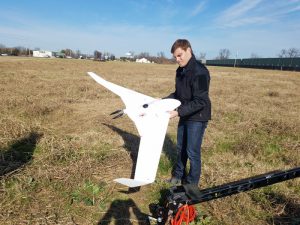
There’s simply no getting around the fact that unmanned aerial vehicles (UAVs) represent the fastest and most cost-efficient technique there is for gathering the survey data your project needs. Companies that fully take advantage of this trend now will be in the best position possible to ensure that their project progresses quickly, and becomes profitable sooner.

The driving force behind this new trend is the growing availability of drone technology. Today we are seeing drones in all sorts of industry settings where they might not have been practical just a few short years ago, simply because the technology involved is now available at price points where it wouldn’t have been previously.

While this development is a good thing overall for those in need of land surveying services, it can also cause problems: the increasing availability of drones has given rise to many amateur UAV operators who feel qualified to offer landing survey services solely based on their experiences as hobbyists. In reality, working with an experienced professional UAV firm is still the best way to ensure you get survey-grade results.

See Also: Demo of a drone project

3D Laser Scanning & Modeling Will Become More Prevalent

3D scanning and modeling is another example of a technology that has played an important role in land surveying services for years now, but is starting to receive more attention in 2017 based solely on how affordable and available it has started to become. In the past, project managers might have shied away from the obvious benefits of 3D modeling technology because they assumed the technology was not within their price range. Now, with the tools involved getting cheaper at a rapid rate, it’s no surprise to see interest in 3D modeling popping up where it might not have before.

The main result of this trend will be that creating detailed 3D point clouds and models before executing a project will cease to be considered an optional extra, and begin to be seen as the cost of doing business. The ubiquity of efficient, inexpensive 3D models across project settings will in turn lead to projects that proceed quickly, without the delays caused by mistakes or inaccurate data. Simply put, 3D modeling will help more project managers run profitable projects, while also ensuring the safety of their workers.

See Also: Demo of web based point cloud

End-to-End Data Systems Will Become More Important

As surveys become more detailed and advanced techniques such as 3D modeling become commonplace, the amount of data project managers must be able to account for will skyrocket. Project managers must ensure that the land surveying provider they choose to work with offers them a solution that is simple, flexible, and robust.

drondataexplorer

By working with a provider that offers an end-to-end data solution, project managers can feel completely confident that all their data is being safely stored, and will be available when and where it’s needed. Since the solution is cloud-based, all project employees will have access to the same data, whether they’re on their mobile device at the work site, or on a desktop in the main office.

To learn more about these and other trends going on in the world of land surveying services, contact the experts at Landpoint today.

Landpoint-CTA-Survey

BIM in Construction: What are the Benefits

In the construction industry, getting the best results depends heavily on using the best techniques and technology available to you. One example of a new technology that many construction projects managers are beginning to take full advantage of is building information modeling (BIM). BIM in construction uses advanced surveying technologies such as 3D laser scanning and unmanned aerial vehicles to gather data about buildings and the terrain around them and then turns that data into detailed virtual 3D models that can be used throughout the planning and design process.

Read on to learn more details about BIM in construction and how it can support better results for your project.

More Informed Decision Making

In the construction industry, the best decisions are based more on evidence and less on guesswork. When a project manager is able to look at a detailed 3D representation of the building in question before making a decision, it’s possible to take guesswork all the way down to zero.

Using the BIM 3D models, project managers can conduct simulations of different situations, allowing them to fully understand the potential consequences of a particular action before they take it. This provides a level of insight that simply would not have been possible in the days before BIM existed, and this new insight will no doubt lead to better project results.

Ensure a More Streamlined Project

One of the key sources of delays in construction projects is the need to make unexpected changes after the project is already underway. The only way to prevent these kinds of delays from occurring is to have a complete and accurate project plan in place before you begin working on a project. In order to create such a plan, you need data that can help you see all angles and account for all possible outcomes. This is where BIM comes into play.

With BIM, project managers are empowered to make sure they get things right the first time around. As a result, they can feel more confident that their project will proceed according to plan, and that there will be no unforeseen interruptions.

A Centralized Source of Up-To-Date Information

When paired with a cloud-based distribution platform like TrueAtlas, building information modeling becomes especially powerful. Pairing these two technologies together helps ensure that everyone can access the complete, accurate information they need, from wherever they happen to be, on whatever device they happen to be using.

As a result, a project team is empowered to collaborate on their decision making, while knowing that everyone involved with the decision is on the same page. This also helps to avoid the difficult situations that can arise when team members aren’t communicating with each other clearly enough. It’s no wonder that 43 percent of organizations that participated in a recent survey from Dodge Data & Analytics said they experienced more efficient project-wide communications after implementing BIM.

Lower Costs

Finally, BIM data can now be gathered using unmanned aerial vehicles. Unlike BIM data created by traditional surveying teams, UAV surveys are mostly automated and can be performed in a fraction of the time. This leads to a reduction in man hours needed to get started on a project, which in turn translates to lower costs.

Also, the increased accuracy that BIM in construction enables also keeps costs down. In addition to being time consuming, unforeseen issues that create the need for rework later on in the project are also very costly. Once again, BIM provides the level of accuracy that’s needed to make sure these issues don’t occur.

To learn more about BIM in construction or to get started with your BIM project, contact the experts at Landpoint today.

landpoint-cta

A Look at How Oil and Gas Surveying is Becoming Less Expensive

When it comes to oil and gas surveying, a project manager’s main goals should be clear: gather the most accurate data possible while also moving quickly and keeping costs down. On that last point, project managers are now able to benefit from of a variety of new and developing technologies that can support the goal of a more cost-effective land surveying process. In this post, we’ll take a close look at a few of those technologies and what they do to cut costs so that you can be informed when the time comes to shop around for oil and gas surveying services.

Unmanned Aerial Vehicles

Unmanned aerial vehicles (UAVs), also known as drones, are popping up in more and more places these days. There’s a very good reason for this: UAVs have always been very useful in a variety of settings, but until the last few years they have been too expensive for many to consider investing in.

Oil and Gas SurveyingTimes have certainly changed: drone technology has become more sophisticated and available, which in turn translates into lower prices, making UAVs cost-effective in many places they might not have been before.

In addition to rapidly falling startup costs, today’s UAVs are also able to keep operating costs lower than traditional surveying teams could for large scale project. This is in large part due to the fact that UAVs are able to cover large areas quickly, which dramatically cuts the amount of man hours required to complete the oil and gas surveying. In addition, UAVs are able to pass over difficult terrain as the crow flies, with none of the delays that would occur for land-based surveyors.

Centralized Data Storage

Today’s oil and gas surveying services are significantly more detailed and accurate than the surveys of the past. Of course, this is a good thing for project managers, but it also creates an unintended challenge: safely storing massive amounts of data.

Storing all that data can be a very expensive proposition, especially if an organization doesn’t have the IT infrastructure needed to do so. Turning to cloud-based data storage, where a service provider manages the actual storage infrastructure, is a great way to defray startup expenses and keep costs manageable.

In addition, maintaining a centralized repository for data can make an organization more efficient, which will generate cost savings as well. All users can be sure they are pulling from the most recent data, with no potential for time-consuming and productivity-destroying version control issues. In addition, the data can be accessed on any device, including mobile devices, which means users don’t need to use special equipment or leave the work site to get access.

Well Documented and Revisited Locations

Oil and Gas Surveying
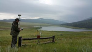
Some of today’s more established land surveyors are extremely familiar with the regions that they service, which can be extremely helpful if you need a land survey. The more knowledgeable a surveyor is with the region, the more efficient they will be when surveying it. Advanced knowledge of an area translates to reduced travel and setup time. It also makes data collection faster as well.

Knowledge of an area can come in two different ways: it may be a region that the surveyor has already visited, or it could be an area in which the surveyor has documentation. Even if they haven’t surveyed the specific area that you are targeting, if they have existing records (or know how to acquire records) of an area, those can be used to streamline the process.

To learn more about the advanced technology solutions Landpoint can offer for oil and gas surveying services, contact our team today.

Landpoint-CTA-Survey

Need Aerial Data Collection? Here are Four Things to Consider

As unmanned aerial vehicles (UAVs) start to become more affordable, they are popping up in a number of industry settings where they might not have been practical before. One instance of this phenomenon can be found in land surveying. Aerial data collection has the potential to revolutionize land surveying for the better, but only if you’re careful to go about doing it the right way.

Before you take the plunge on aerial data collection for your land surveying needs, read this blog post for a closer look at several of the things you should keep in mind in order to help you get the best results. These points will help guide you as you look to hire a provider of aerial data collection for land surveying services.

1. Does the Data Provide Survey-Grade Accuracy?

First and foremost, accuracy is the name of the game when it comes to aerial data collection. There may be some areas of your project where “close enough” is good enough, but the accuracy of your survey data should not be one of them. At the end of the day, if your survey doesn’t provide accuracy that you can use to support informed decision making, then all it really is just a pretty picture.

Make sure you work with a land surveying partner that can demonstrate knowledge and experience with the latest drone mapping techniques. In addition, look for a company that has invested in the most advanced data collection technology available.

aerial data collection

2. Is the Person Flying the UAV A Certified Pilot?

As mentioned earlier in the post, drones are now more affordable than they have ever been. One of the drawbacks of this fact is that it creates a situation where just about everyone feels that they are qualified to operate a drone. However, just because someone has experience using drones as a hobbyist does not mean that you should trust them to conduct your aerial data collection.

For one thing, working with a sUAS certified pilot is the only way to make sure your organization gets complete and accurate data to support its land surveying efforts. In addition, drones in industry are still highly regulated, which means that you may open yourself up to legal trouble if you choose to work with someone who isn’t a sUAS certified pilot.

3. How Is the Data Going To Be Processed And Stored?

What happens to your survey data after it’s first collected is perhaps just as much of a concern as the actual data collection itself. Accurate data is important, but it can’t do you any good unless it’s processed quickly and correctly, provided to you in a useable format, and stored in a way that makes it easy for you to access in the future.

When you meet with potential providers of aerial data collection services, make sure to spend some time discussing their data processing methods. Ideally, they should be able to provide you with processed and useable data within a time window of 24 to 48 hours. Ensuring prompt turnaround for your land surveying data is an important part of ensuring your project proceeds according to schedule.

4. How Advanced Is The Drone Being Used?

aerial data collection

Like everything else in life, the equipment you use for your aerial data collection process matters. Working with a team that has access to the latest in UAV technology is a great way to make sure the data you end up with is accurate, but also gathered quickly and cost effectively.

An example of this can be found in the issue of ground control points. Less advanced UAVs must always set these points in order to ensure accuracy, which can be very time consuming. Newer drones are able to ensure accuracy without them, which leads to a quicker collection process.

To learn more about aerial data collection services, contact the experts at Landpoint today.

landpint-UAV-CTA