Getting an As-Built Survey for an Oil and Gas Facility? Consider a BIM

Oil and Gas Facility, As-Built Survey

If you’re in the process of building or retrofitting an oil and gas facility, getting an as-built survey is just one of many different things you’ll need to worry about. However, by employing the latest technologies, you can make sure that the process of getting a high-quality as-built survey is simple and efficient. As a result, you’ll have more time and resources to focus on actually completing your project.

In this post, we’ll discuss how building information modeling (BIM), created using 3D laser scanning technology, can help you get the best possible results from your as-built survey.

What Is 3D Laser Scanning and How Does It Apply to BIM?

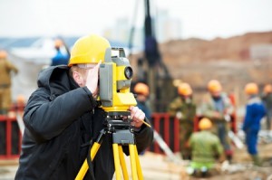
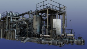
With 3D laser scanning, a surveyor would set up a series of scanners that will let out thousands of individual laser points. After the laser points bounce off the building in question, their flight path will be tracked as they return to the scanner. Data from individual laser points will be compiled into a point cloud, which can provide a very detailed and accurate representation of the building and its composition.

The point cloud from a laser scan can then be used to create a BIM model, which is a 3D digital representation of the data provided by the scan. Many software platforms can even create the BIM models automatically for certain piping features. Creating BIM models based on data collected by 3D laser scans can help you in a number of ways.

They Help You Complete Projects Faster

Traditional surveying methods can be incredibly time consuming. A surveyor must enter the site and manually take points of the things they wish to survey. The process of assembling these points and formulating them into something that can actually be used to create an as-built survey is extremely slow and can often result in delays to the project itself.

On the other hand, laser scanning is a very quick process. Data is collected and assembled into a BIM model automatically, meaning that your team does not have to wait to get the as-built survey they need.

They Help You Reduce Potential Errors

Individual points are not always reliable when it comes to as-built surveys, as they can be affected by line of sight or GPS errors inside of the facility.

On the other hand, surveying based on laser scanning is both very detailed and accurate. The data gathered by 3D laser scanners will always be the same, no matter what conditions they are acquired in. This, in turn, means that the BIM models you create using laser point clouds will always be accurate. The 3D model you end up with will always be a model of what actually exists. Once you have the BIM, you can use it to make project decisions with confidence.

They Help Reduce Construction Costs

Finally, it’s important to think about how you can keep costs down as you complete your as-built surveys. Traditional surveying methods can lead to inflated costs, because they require more man hours to complete. In addition, the fact that these surveys aren’t always accurate can contribute to expensive rework, while delays in completing these surveys make it harder to achieve a quick return on investment.

By contrast, BIM models based on 3D laser scanning are completed with a high degree of automation, meaning fewer man-hours, reducing the overall cost. Because they are so accurate, a BMI will also help you to reduce the number of costly errors that can pop up during a project, further reducing the cost for oil and gas companies.

3D laser scanning and building information modeling are certainly valuable tools to support your efforts to get a better as-built survey for your oil and gas facility. However, in order to make the most of the benefits offered by these technologies, you need to make sure you’re working with a land surveying partner that knows how to use them. To learn more, contact Landpoint or review one of our project examples to get a look at what we’re capable of.

landpoint

How New Surveying Technology Keeps Infrastructure Projects on Budget

Land Survey Cost

When it comes to completing major building projects, municipal governments and infrastructure engineering companies face a variety of unique challenges. While these projects have many of the same standards for accuracy, efficiency and safety as any other project, they must also make the most of the limited funding available to them. Since funding for infrastructure projects comes directly from taxpayers, municipal governments are beholden to make the most of that funding.

One way engineers can do this is to keep the land surveying cost down. By working with an experienced land surveying partner, government agencies will be able to take advantage of innovative new technologies that offer the same quality of surveying results at a small fraction of the price. As a result, governments will be empowered to move forward with their building projects with as little wasted funding as possible.

This post will provide a brief overview of some of the technologies that can keep land survey costs down on infrastructure projects.

Unmanned Aerial Vehicles

Unmanned aerial vehicles (UAVs), also known as drones, are increasingly being used in a variety of different industries, and land surveying is certainly no exception.

The cost savings that UAVs represent in land surveying can all be traced back to efficiency. Traditional land surveying methods require surveyors to travel over active areas to complete their work. This can be an excruciatingly slow process. Also, the larger the project area and the more difficult the terrain, the longer the survey will take. In addition to increased man hours, these manual surveying efforts frequently delay the start of actual project work.

By contrast, land surveying conducted using UAVs can cover large areas in a short period of time. In fact, some drones are able to survey 400 acres in a single hour. The data format these surveys can be processed and made available to engineers back in the office quickly. As a result, engineering firms can spend less money on up front and throughout the design phase, helping to ensure that their projects come in at or under budget.

xuavhowto2.jpg,q9dae55.pagespeed.ic.Kww0BUlVYS

Finally, today’s UAVs can make use of increasingly inexpensive HD cameras and photogrammetry to capture detailed and accurate images from above. This ensures that agencies do not have to sacrifice the quality of their results just to save money. As these cameras become more affordable, the cost of using UAVs to provide land surveying for infrastructure projects will only continue to decrease accordingly.

3D Laser Scanning

3D laser scanning, also known as LiDAR, is another example of a technology that can be used to quickly gather land surveying data. The results of 3D laser scanning can be used to create very detailed models and survey documents.

In 3D laser scanning, a land surveyor sets up a series of scanners that emit thousands of laser points, which would then bounce off the building or terrain that’s being scanned. The flight path and trajectory of the laser beams is tracked as they return to the scanners. The scanners would then assemble the data from the various laser points into a single data cloud, which provides an extremely detailed representation of the object being scanned.

Like unmanned aerial vehicles, 3D laser scanning allows very detailed survey information to be gathered in a small fraction of the time needed to conduct traditional land surveying. This means that using 3D laser scanning can help decrease the labor costs involved with any major building project. In addition, the detailed models laser scanning helps create can increase the accuracy of land surveying work. This supports lower costs by removing the potential for expensive mistakes later on in the project.

With years of experience surveying roads, bridges and public utilities, Landpoint understands the unique challenges infrastructure projects face. We also have the technology needed to overcome those challenges. Contact us today to learn more about our services.

landpoint-cta

Drone Surveying: The Advantages of Using Drones for Agriculture & Forestry

Drone Surveying

While drone surveying certainly has important applications within the construction and mining industries, many people don’t realize that the significant role drones will play when it comes to land management in forestry and agricultural settings. By conducting quick and accurate surveys from above, unmanned aerial vehicles can help land management agencies gain a much better understanding of what’s happening on ground level, which will, in turn, empower them to make informed decisions. In this post, we’ll take a brief look at some of the advantages of using drones for agricultural land management purposes.

Advantages of Using Drones for Agriculture & Forestry

Understanding Land Health

One of the most important, yet most challenging, charges faced by any land management agency is making sure the area under their supervision is healthy. If they aren’t careful and attentive, plant-based diseases can cause significant damage to forests and agricultural land before the agency in question even realizes what’s happening.

UAV surveying can help alert land managers to any possible signs of problems so that they can respond before things get out of hand. In addition, UAVs can be outfitted with NDVI cameras that use infrared and thermal imaging to create detailed models. These models allow land managers to take a proactive approach to plant health. Instead of waiting for symptoms of a disease to show themselves, land managers can make a plan to take targeted samples.

While taking samples using traditional land surveying technology can be extremely costly and time-consuming, starting with a 3D model allows the agency to be smarter about when and where they take samples. As a result, they are able to get the even better results with a fraction of the headache.

Understanding Economic Impact

While a land management agency’s first priority should be to protect the land that it manages, it can also play an important role in helping businesses and other commercial interests take advantage of the economic value of land, while doing so in a socially responsible manner. For all of the many different factors that go into managing forests and farmland as economic resources, UAVs can help out tremendously.

One of the first steps in making sure that land is being used responsibly is to detect signs of illegal land use, such as unsanctioned logging. Illegal land use may be very difficult to detect using traditional surveying methods, particularly when an agency has very large areas of land to manage. However, UAVs are capable of surveying as much as 400 acres in a single hour, making it very difficult to hide any illegal activity that may be going on in an area.

In addition, UAV surveying can be used for purposes of inventory assessment. In order to fully capitalize on the economics of land, an agency must be able to place an accurate value on a piece of land, allowing for proper levels of taxation. This can’t be accomplished until the agency has a full understanding of the piece of land, and the economic resources it may contain. Using UAVs makes it much easier for an agency to gain this level of understanding.

While the benefits of UAVs as a land surveying technology are impossible to ignore, it’s important to realize that you must work with the right land surveying partner if you hope to really make the most of using drones for agricultural purposes. At Landpoint, we are here to help. We understand the challenges that land management agencies face, and we have direct experience using UAVs to help them overcome these challenges. Review an example of our land management work to get an idea of what we’re capable of, or contact us today to find out more about what we can do for you.

landpoint-ebook-cta

Image Source: Richard Unten

How 3D Surveying Can Help With Your Retrofit Project

3D SurveyingThere are a number of reasons why industries use 3D surveying when retrofitting facilities. As a facility ages, the need for updates becomes greater to ensure it is equipped to handle evolving developments in technology while providing the data needed to make sound engineering decisions. Conducting a laser scan during the initial process to create a 3D model that will assist in pinpointing the areas that need the most updating, helping focus your resources while saving money.

What Is A 3D Survey?

A 3D survey is a laser scan that assists in pinpointing as-built areas within a structure or facility to determine the integrity and viability of improvements to make sound, educated decisions. Landpoint’s 3D surveys are used to create models that capture all the data of a structure, converting it into a document that is easy to understand. These models and point clouds help promote the timeliness of a project, cutting down on processes that can be cumbersome and lengthy.

How Can 3D Surveying Help My Organization?

3D surveying can assist in a number of ways:

Accuracy

Knowing your facility and how it operates is key when formulating a plan for upgrades. The existing structure, its measurements, and other areas that may be impacted is key when considering a project of this nature. Utilizing a 3D point cloud will illustrate any project inquires with unequivocal accuracy as the model scales in real-time.

Identifying Areas of Concern

Retrofitting oil and gas facilities can be complex. Having the resources and data available to identify potential issues before they occur saves time and money. There are many instances where projects have been delayed due to issues that have surfaced. A 3D model and point cloud helps find these issues in advance to plan ahead and formulate solutions before they are needed.

Improves Efficiency

Having an effective plan in place helps to keep the project running on time and on budget. The planning phase is one of the most, if not the only, area that closely evaluates the viability of the project and overall impact of any changes. 3D models will help in the gathering of data to monitor and develop a successful project. Having a clear picture of what is needed will assist in maintaining the integrity of the project while increasing efficiency and production.

A Look at Landpoint’s 3D Surveying and Modeling Services

A perfect example of how Landpoint used 3D surveying to assist our clients is the Ogilvie Hardware renovation project. This historical structure was scheduled for renovation and slated for structured housing. We scanned the structure and provided detailed models to assist the architects and engineers in retrieving the information they needed to move forward. In total, Landpoint created a historical preservation model, construction support diagrams, a 3D PDF and animated video for the client, which assisted in the redevelopment efforts of this structure, which is now filled with loft apartments.

At Landpoint, we take pride in ensuring our clients have what they need to make their projects successful. Models can be created for any industry that needs to determine the integrity of a structure or land mass that is being considered for use. Our team has years of experience, utilizing the best technology available. We can create 3D models and point clouds that can be converted to any format your team needs. We also have the ability to create 3D models from control points, rough drawings, or blueprints when needed.

For more information on how 3D surveying and 3D models can enhance your project, contact a team member at Landpoint for a consultation.

landpoint-cta