How to Get Improved Accuracy in Your As-Built Surveys

as-built surveysOne of the most critical factors in construction is keeping a project on track. Too often, inaccuracies caused by human error, lack of organization and inefficiencies in the process can quickly derail a project. Suddenly, a construction project that had been moving along smoothly becomes a challenge to keep on schedule.

Regardless of whether you are in the oil or gas industry surveying a prospective new site, or in some other field embarking on a construction project, the last thing you want to worry about is reliance on inaccurate information. Mistakes along the way, like reliance on an inaccurate as-built survey, can cost the entire project in both time and money—and make it difficult to get back on track with either.

As-built surveys are critical to ensure construction projects proceed safely and accurately, but even minor errors can add weeks to the production schedule. While it may seem there is not much a project manager can do to assure accuracy of a survey or the process that follows, two technologies available today can give a boost to confidence and put project managers back in the driver’s seat when it comes to project progress.

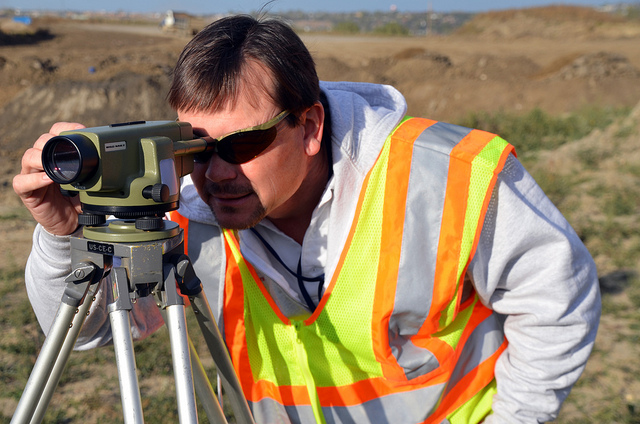
Terrestrial Laser Scanning Reduces Human Error

One of the ways new technologies are helping to improve project accuracy is through 3D laser scanning. Rather than having to move from point to point on a job site to gather all the necessary information needed to complete the as-built survey, this technology enables surveyors to use terrestrial laser scanning to compile all the information they need. From there, they are able to build accurate 3D models that provide the necessary detail to complete their work. Turnaround time is shaved from a few weeks to a few days, but just as critical, human error is nearly eliminated from the equation.

Also known as LiDAR data collection, terrestrial laser scanning works by bouncing laser beams off the area to be surveyed. The scanner records a point every place the laser hits a surface. The result is an enormous “point cloud” made of millions of survey grade points. The individual points can then be connected to create a detailed representation of the job site environment.

Project Management Suite Assures Accuracy

The second piece of technology providing improved accuracy to the construction process is a cloud based project management suite. A project management suite serves as a central hub for your entire project. Anyone involved in the project and holding access to the management suite can view, upload and download the most current versions of critical project documents.

Gone are the days of wondering whether or not you have the most current information relating to the project. Instead, you and the other project stakeholders can feel confident you are looking at the most recent, most accurate documents available. Rather than keeping track of document versions, the project management suite keeps track of those details for you. The results are accurate, up-to-date materials that all parties can access, even from a mobile device out on the job site.

To learn how these new technologies from Landpoint can improve accuracy of your as-built surveys and keep your project on track afterward, contact us today.

Image source: U.S. Army Corps

The Biggest Roadblocks to Getting Pipeline Surveys Done

pipeline surveyingThe pipeline construction process start and end with surveys to document topography, plan routes, and record the as- built status. Congested pipeline right-of-ways today make accurate surveys critical to planning routes. Whether front-end or backend, pipeline surveying needs to be done fast to meeting deadlines and make the pipeline operational.

Make sure your surveying company can overcome these hurdles during the pipeline construction process:

Pipeline surveys need to get done fast. Surveys need to be completed on time to meet proposal due dates and avoid pushing back project deadlines. But you can’t speed up a survey if it means losing comprehensive data. The only way to get all the data needed quickly is to use all the advanced technology available, rather than relying on manual surveying methods.

Speed up pipeline planning by using UAVs. Unmanned aerial vehicles (UAVs) can cover ground quickly, capturing high-accuracy data. Long battery life means a single UAV can complete a large scan. Mobile devices and a sophisticated data communications network transmit data quickly and cloud-based project management makes it available anywhere.

UAV scans are also great when questions come up while work is already in progress. They can provide a quick look that shows how the project has evolved and help figure out how to respond to problems or opportunities.

Pipeline survey areas are bigPipeline surveying covers miles, not a few acres in someone’s backyard. The same tech that helps meet time constraints helps cover the ground. UAVs can survey 400 acres per hour and aren’t slowed down by rough terrain. UAVs can conduct scans from lower altitude than manned aerial vehicles, meaning they collect better data. This is the only way to cover a large survey area effectively in terms of accuracy.

Because UAVs reduce the need for pilots in the air or surveyors roaming the ground, safety is improved, too. The UAVs also have a high level of accuracy, meaning fewer problems in the field later.

Pipeline surveying captures a lot of dataBecause of the large distances surveyed and the large amounts of data captured by laser scanning, an immense amount of data is created. Modern oil and gas pipelines, which need to be routed through more populated areas, need a high level of detail that basic topographical maps don’t provide.

But the data is only valuable if it’s usable, which means putting it into multiple formats, using GIS applications that provide detailed maps and support analysis, and using a cloud-based project management site to keep data available and streamline the workflow.

The GIS systems go beyond topographical maps to highlight geographical issues and environmental constraints plus existing pipelines, easements, and other factors. Having the data in the cloud means authorized users can access the files from anywhere there’s an Internet connection. You don’t need to worry about bringing the right printouts with you; as long as you’ve got a smartphone or tablet, you can call up the exact view you need.

Overcome the Roadblocks

The best way to get around the roadblocks common to oil and gas pipeline construction is to work with an experienced team—professional surveyors, GIS analysts, CAD technicians, engineers, and other technical experts—that uses the latest technology, high quality instruments, advanced data communications, and project management methods. Put all these together and pipeline surveying can be completed quickly and accurately, giving pipeline companies the information needed to plan, build, and operate their pipelines.

Landpoint is expert in applying technology to the pipeline construction process and can provide pipeline surveys covering miles of ground. Contact us for more information about pipeline surveys we’ve completed and how we’d complete yours.

Image source: Maureen

Unmanned Aerial Vehicle

What Factors Do You Need to Consider When Looking for 3D Laser Scanning Services

Before starting a construction project, you need to know what’s already out there. The more information you have up front, the fewer surprises you’ll encounter once work gets started. Laser scanning offers the most detailed and specific information you can get in a map or survey, as it bounces lasers off of targets to form a precise point cloud. To make sure you get the most benefit from using 3D laser scanning services, keep these questions in mind:

How good is the captured data?

A map that isn’t based on good data is at best a pretty picture. Compared to other surveying techniques, 3D laser scanning is a high-definition process that captures millions of data points. Modern scans are accurate to within 4mm, making maps generated from this data extremely useful for planning purposes.

How quickly is the data available?

Depending on who you go with for you 3D laser scanning services, data can be acquired from the ground or from the air. Scanning from the air can be completed quickly, as drones can cover 400 acres per hour. Drones travel faster than land-based surveyors because they can just fly over rough terrain without being affected by it. Aerial scans can also be quicker to perform because drones can be operated remotely; the operator doesn’t need to travel with the machinery.

How usable is the data?

It doesn’t matter how quickly you get the 3D laser scan survey if it doesn’t provide the data in a format you can work with. These days, simple PDF files of a topographic map aren’t nearly flexible enough, but at the same time, you can’t work directly with the hundreds of gigabytes of raw data captured during the mapping process.

The captured data point clouds need to be turned into digital elevations and other 3D models. GIS and other analytics software let you work with the numbers, while virtual reality technology can literally let you walk through the mapped environment.

It’s also important to be able to access the 3D scan output from anywhere, on any device, at any time even—or maybe especially—when workers are out in the field. When data is stored “in the cloud,” it’s always accessible, wherever you are. Having the scan always available means you can easily use the map to adjust your plan to the current circumstances, rather than being locked into an early decision or having an expensive delay while an issue is sorted out.


Check out this demo of accessing point cloud information directly from your browser. You don’t need any special software and the point clouds are hosted as a service instead of having to download hundreds of gigabytes of data.

How experienced is the firm doing the mapping?

The oil and gas boom has led to a corresponding boom in surveyors, but new companies don’t have the experience to get the job done right. Because important decisions are made based on what the map shows, it’s important to work with an experienced surveying firm. Make sure the firm has a history of success in working with current technology.

How expensive will it be to capture the data?

It’s almost impossible to avoid cost as a factor in your decision making process. You need to get the data you need, but in a cost-effective way. A 3D laser scan survey done from the air, using UAVs, are often cheaper as well as quicker and safer than ground-based surveys. Keep in mind that data you can use flexibly is more valuable than data that isn’t flexible, so a higher up-front cost can be more cost-effective when you take a long-term point of view.

Having a good map helps you find your way, make better, more cost-effective plans and document the legalities of infrastructure. If you want to capture the data you need to manage your project, contact Landpoint to find out how our 3D laser scanning services will help you get your job done.