Professional Land Surveying: Then and Now

Like so many other services, professional land surveying has changed greatly over the years, based on the development of new technologies. What makes land surveying unique is its long and complex history, and understanding that history can be important to comprehending the current state of land surveying procedures. Read on for a brief overview of land surveying history, followed by a look at some of the technologies that are driving land surveying into the future.

Ancient Times & The Middle Ages

First of all, it’s noteworthy that land surveying has played an important role in human society for almost as long as there has been human society. According to the History of Land Surveying from Purdue University, the original land surveyors were ancient Egyptians, who needed to create precise and accurate plots of land for the purposes of taxation.

From there, land surveying would go on to play a pivotal role in other great civilizations. According to the German website Vermessungs-Suchmaschine, land surveying enabled many of the feats of engineering that defined the Roman Empire. In order to complete their impressive construction projects, the Romans made many advancements in the field, including the organization of a surveyor’s guild and the introduction of many early surveying instruments.

Like many other fields of study, land surveying languished in Europe during the Middle Ages, with very few new developments occurring during this time. The Domesday Book, created in 1086 in the aftermath of the Norman Conquest of England, was one impressive example of a land surveying project during the Middle Ages. However, the level of accuracy provided by the document certainly does not live up to modern standards.

Colonial Times

During the colonial era, European powers like France and Great Britain needed detailed maps to back up their land claims in the New World. This fact led to the development of new, more advanced surveying techniques. Coincidentally, it also led to the career of perhaps the world’s most well-known historical surveyor: George Washington. Before he became a military and political leader in the early United States, young George Washington got his start as a land surveyor in western Virginia.

Professional Land Surveying Today

Land surveying has certainly come a long way over the years, and today’s surveyors are able to work with technologies that those coming before them could only have dreamed of. This is not to suggest that today’s land surveyors are better or more capable than those of the past; they merely have a more advanced tool set, which allows them to create more accurate results.

Land surveying has played a pivotal role throughout history, and the technology and techniques land surveyors use have always been influenced by what’s going on in the world as a whole. Whether it’s collecting taxes, building roads and aqueducts, or pushing west into an unknown continent, land surveyors have always found ways to meet the needs of their employers, and things are no different today.

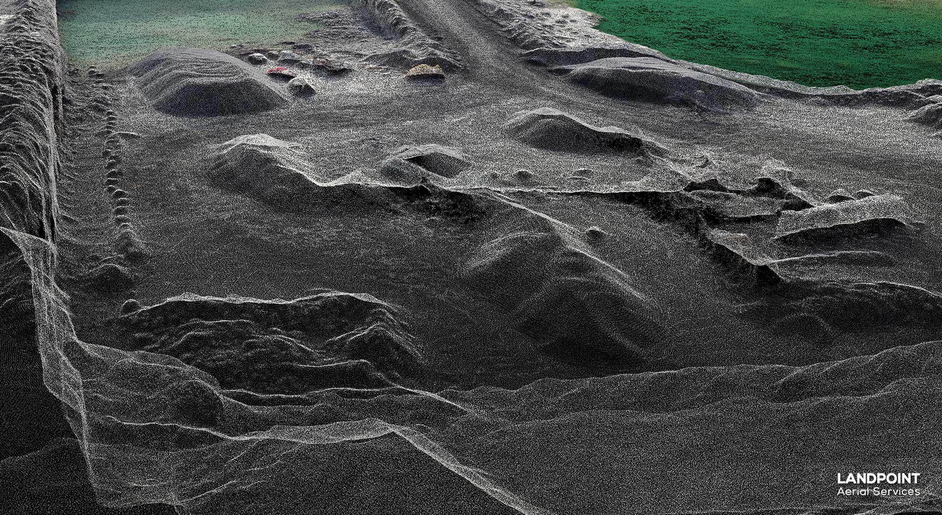
With land values at all-time highs, and growing concerns over sustainable building practices, today’s land surveyors are under a lot of pressure to work both quickly and accurately. That’s why they’ve come to rely on technologies like Unmanned Aerial Vehicles (UAVs), 3D Laser Scanning, and GIS.

UAVs, commonly known as drones allow land surveyors to operate from above, quickly gathering large amounts of information at a very high level of detail. This data can then be used to create multiple types of deliverables such as point clouds, digital elevation models, and othro imagery.

With 3D laser scanning, land surveyors are able to track the path of a series of laser points as they leave and return to the scanner. Surveyors are then able to put together very accurate 3D models as this technology is one of the easiest ways to get a detailed look of an area.

Http iframes are not shown in https pages in many major browsers. Please read this post for details.

Finally, GIS mapping technology allows land surveyors to conduct more detailed data analysis by creating a visual representation of spatial relationships. This makes it easier for surveyors to make good decisions about where to conduct projects.

Final Thoughts

Today’s professional land surveyors are able to complete work that would never have been possible in the past, which is why you’ll want to make sure you’re working with a surveyor that knows how to make the most of the latest technologies available to them.

Contact Landpoint today to learn more.

Image Source: Bureau of Land Management

landpoint-cta

Why Land Survey Services Are Becoming Cloud Connected

Point Cloud

In a complex, data intensive business like land surveying, making the most of new technological opportunities will always separate the most successful organizations from those that struggle to keep up. This is especially true when a new technology can help land surveyors save money, operate more efficiently, and get better results overall. When a single technology can do all three of these things, adopting that technology becomes a no-brainer.

This is the case when it comes to cloud computing. Although cloud has already been used with great results in a variety of industry settings, it’s especially well-suited to those who need land surveying services, so it’s no surprise that land surveyors have begun to adopt the new technology.

If you’re in the market for land survey services, read on to learn a few of the ways that working with a cloud-ready land surveyor could benefit you.

1. Get the information you need faster

With any construction project, the ability to meet deadlines is based on how well the different teams involved can communicate and share information. By storing survey data in the cloud, all of these different teams can quickly and easily access the information they need as soon as it is approved and uploaded. So, for example, if a new as-built survey is uploaded, then the project manager, the engineer, and anyone else who needs access to the information instantly has it.

It’s even possible to get some data directly from the field. Thanks to mobile technology, data can be uploaded on-site to a cloud platform, allowing near-instant access to it. This greatly increases efficiency and help ensure that projects remain on schedule.

2. An easy way to keep everyone on the same page

When multiple versions of the same document are floating around within a project team, it can never be a good thing. Unfortunately, with spread-out projects, which include workers in the office and in the field, it can sometimes be a challenge to keep everyone on the same page.

The cloud helps alleviate this problem as well. With a cloud-based project management suite, an organization can feel confident that everyone is getting the most recent version of documents and information from a single centralized location. Crucially, remote employees can upload directly to the project management platform from their mobile devices, meaning that they are never out of the loop. As a result, a land surveyor operating in the cloud should always be able to provide a single version of the truth for your project.

3. The cloud is perfect for archiving data

Need to find on older as-built survey from several years ago? If all of your survey data has been stored in the cloud, then it becomes a simple matter of logging in to your account and finding the right document. Various types of survey data can easily be archived in the cloud, meaning you don’t have to worry about it getting lost.

Since the cloud provides a single location to upload and store all data and images that are collected by a land surveyor, it can help greatly reduce the amount of rework a surveyor has to do. Any time a surveyor has to pick up on a project after a period of time, or return to an area they have already worked in, they will have instant access to all the work they have done in that area previously. As a result, they will be able to start any of your future projects with no rework, saving you time and money in the process.

To learn more about how land surveying services with a cloud-ready platform can benefit you, contact Landpoint today.

landpoint

The Biggest Survey Challenges for Solar Energy Projects

Solar Energy Development, Solar Energy Survey, Solar Energy ConsultantWith the world’s growing energy needs, it’s becoming increasingly clear that the energy industry will continue to diversify and expand. As a result, there is now greater interest in renewable energy sources, with solar energy being among the most popular. According to the Solar Energy Industries Association, solar accounted for about 40 percent of all new energy producing capacity to come online during the first half of 2015. The growth in solar energy production has occurred both on a small-scale residential basis and a large-scale utilities basis, with a new solar energy project being installed every two minutes.

With so much interest in solar energy as one method of fulfilling our future energy needs, it’s no surprise that there is also growing interest in how to turn out efficient solar energy projects. As with many development projects, land surveying is one of the first and most crucial components. The solar energy industry has some unique challenges when it comes to land surveying. Working with a land surveying firm that has direct experience working on renewable energy projects is the best way to address these challenges, but for now, read this post to get a brief introduction to the subject.

The land surveying challenges facing the solar energy industry

Like any large development project, utility-scale solar energy development projects require detailed and accurate land surveys that can be turned around quickly. The unique challenge that solar energy projects face is that they often cover very large areas, making it challenging to complete the surveys quickly.

Traditional land-based surveyors will have difficulty covering such large areas in a timely manner, and when they have finished their work, they still have to return to an office to compile their results before the engineering staff can begin drawing insights from them. Taken together, these factors account for a very slow information gathering process, which greatly increases the expected time to value for a large-scale solar project.

In addition, while accuracy is always important for land surveys, the bar is set especially high for renewable energy projects such as solar. In order to maximize their effectiveness, solar energy collectors must be properly located; this in turn requires the availability of very accurate land surveys. Even a small inconsistency could result in a solar installation that is not as effective as planned. Once again, traditional land surveying methods may not be good enough to get the job done.

Address these challenges with unmanned aerial vehicles (UAVs)

To meet the unique challenges of new energy production technologies, it is necessary to work with new land surveying technologies. For example, unmanned aerial vehicles (also known as drones) can complete land surveying work in a way that is highly superior to traditional land surveying methods, making it a perfect choice for solar energy projects.

Check out some of the standard imagery and data sets we provide, directly from your browser. You don’t need any special software and the data is hosted as a service instead of having to download hundreds of gigabytes of data.

Landpoint’s UAVs can be set to follow predefined routes, allowing them to cover large areas of terrain in a relatively short period of time. In addition, UAVs are able to relay their findings back to engineers in the office, essentially removing the waiting period involved with gaining insights from land surveying projects. This fact makes UAVs especially well-suited to support solar energy projects, which can often span very large areas.

In addition, UAVs are capable of creating very accurate land surveys, which is another must for solar energy projects. Equipped with today’s high-definition cameras, UAVs can capture land surveying images with resolution as high as 1 centimeter per pixel. UAVs are also able to fly over difficult terrain and get themselves into and out of tight spots easily, a factor that allows them to get a much closer look than traditional land surveying methods could. For all these reasons, UAVs are capable of getting the very accurate surveys that solar energy projects require.

To learn more about land surveying technologies for solar energy projects, contact Landpoint today.

A Look at How Modern Wind Energy Surveys Are Changing

Environmental Review, Oil and Gas surveyingWith rapidly increasing energy demands, combined with a growing interest in pursuing renewable energy options, it’s no surprise that alternative energy technologies such as wind and solar have begun to catch on in a big way over the past few years. In fact, according to the Wind Energy Foundation, wind power is the fastest growing source of electricity production in the world today. Within the United States, wind became the leading source of new electricity-generating capacity for the first time in 2012, with over 42 percent of all new energy capacity during that year coming from wind power.

The rapid growth in the use of wind energy has given rise to the need for more land surveying services to support new wind developments. Wind energy projects have their own unique set of challenges that aren’t always found within traditional land surveying projects, which is why it can be helpful to work with a land surveying firm that has direct experience with wind energy surveys if you have a wind energy project on the horizon.

In this post, we’ll examine a few of the things that make wind energy unique and challenging from a land surveying perspective, and take a look at how new land surveying technologies are helping to address the challenges.

The Unique Challenges Involved With Wind Energy Surveys

The first main challenge companies face when conducting wind energy surveys is location. Wind energy developments often need to cover large areas of land in order to be viable as an energy source, and only certain locations are ideal for wind energy production. Compounding the issue is the fact that these ideal locations may be in isolated areas, making it difficult to secure land surveying information quickly.

In addition, wind energy also requires very accurate land surveys. The location of a wind energy turbine is a very important factor in how effective it is in producing energy, so the margin of error on wind energy surveys is comparatively low.

Responding to the Challenges

In order to create wind surveys that can cover large distances quickly, often in far-off locales, and provide a very high degree of accuracy, there are a variety of modern technological developments that land surveying firms can apply.

Unmanned Aerial Vehicles (UAVs)

Unmanned aerial vehicles, also known as drones, are one important technology that modern land surveying firms are using to address the challenges of wind energy projects. UAVs can cover long distances quickly by traveling as the crow flies, allowing them to avoid any terrain issues that would inevitably cause delays for land-based surveyors. In addition, Landpoint’s UAV platform can relay information back to engineers in the office as the information is captured, greatly reducing the amount of time a company has to wait in order to start taking action.

Check out some of the standard imagery and data sets we provide, directly from your browser. You don’t need any special software and the data is hosted as a service instead of having to download hundreds of gigabytes of data.

Finally, Landpoint’s UAV’s can be equipped with relatively inexpensive high-definition cameras, allowing them to capture land surveying images with a very high degree of accuracy. Combined with the fact that UAVs are able to fly very close to the ground and put themselves in locations that manned aircraft would have difficulty reaching, this helps UAVs provide the level of accuracy that wind energy surveys demand.

LiDAR

Another technology that helps support modern wind energy surveys is 3D laser scanning, also known as LiDAR. LiDAR works by having a series of scanners bounce thousands of laser points off of a building or terrain. As the lasers return, the scanner captures their flight path and compiles the data into a point cloud that can be used to create a very detailed 3D model of the site. LiDAR can be performed from the ground, or in conjunction with a UAV.

To learn more about land surveying technologies for your wind energy project, contact Landpoint today.

What Type of Results Can You Expect From a Survey Made by a UAV?

UAV surveyTaking advantage of new technologies is a good way for a firm to accelerate their building projects and get a leg up on the competition. However, understanding those new technologies and the benefits they can offer can be difficult for companies that have not had prior experience with the technology.

One example of this situation can be found with unmanned aerial vehicle (UAV) technologies, also known as drones. Everywhere you look, it seems there’s someone who is extolling the virtues of UAVs and holding them up as a transformative technology that will completely shift the way we do business. However, as is so often the case, many people are still confused about the exact benefits of UAV technology and how they can maximize its use.

In this post, we’ll aim to clear up this situation by talking about exactly what you can hope to get out of applying a UAV survey to your projects.

Approximately 400 Acres Surveyed Per Hour

The first thing you should know about UAVs is that they are capable of surveying large areas in a relatively short period of time. This is part of what makes them so attractive for large-scale construction projects. In the past, the process of gathering land data using traditional surveying methods might have been one of the most time-consuming aspects of an entire project. Now, surveyors are able to gather all the land data they need in just a few hours, even for very large projects.

24 Hour Turn Around

In addition to speeding up the process of collecting data for land surveys, UAVs also help speed up the process of turning that data into useful models. UAVs are able to relay images of the land back to engineers instantly, resulting in engineers not having to wait to begin their work. As a result, UAVs can help projects move forward much quicker than they would by using traditional methods.

A Variety of Applications

UAVs aren’t just used for one particular purpose when it comes to land surveying. In fact, there are actually three main types of UAV surveys that a company might choose to perform:

  • Orthomosaics: This simply refers to a combination of many individual photos to form a single image that has a uniform scale and completely lacks distortion.
  • Vegetation index: Often used in agricultural settings, a vegetation index helps determine where there is plant life and how healthy that plant life is.
  • Digital surface modeling: These models are used to accurately demonstrate levels of elevation in an area, including the elevation of buildings and other objects.

Significantly Cheaper Than Traditional Collection Methods

As the technology behind UAVs has become more affordable, the cost of funding a UAV data collection survey has plummeted, reaching the point where it is now much cheaper than traditional land surveying methods.

The primary reason UAV surveying is so inexpensive is that the UAVs are able to cover large distances quickly, without having to travel over varying terrain. This eliminates the costs involved with the  land surveyors physically covering the site and reduces the amount of man hours the work requires.

Ability to Access Maps From Any Device

Finally, UAV surveys create maps that can be accessed from anywhere. This is very useful on all projects, as team members in the field will be able to pull up the maps on their mobile devices and feel confident that they are seeing the exact same thing that the office staff is seeing when they access the maps from traditional workstations.

If you’re looking for a way to make land surveying quicker, cheaper, and more accurate, Landpoint is here to help. Contact us today to learn more about UAV surveying or to get started with your UAV survey.

Image Source: MIKI Yoshihito

Four Environmental Review Issues That Come up During Oil and Gas Projects

Environmental Review, Oil and Gas surveyingFor oil and gas companies, making sure that their projects comply with all pertinent environmental regulations is of the utmost importance. In addition to demonstrating good corporate citizenship, looking out for possible environmental problems in advance is necessary in order to avoid possible delays and reroutes once the project has already started.

Oil and gas projects are unique when it comes to environmental compliance because they tend to cover large areas and multiple jurisdictions with different sets of regulations. As a result, it can be helpful to work with an environmental consulting firm that understands the unique challenges that oil and gas companies face involving environmental regulations.

Read on to learn about a few of the environmental issues your oil and gas project may encounter.

1. Endangered species

Animal life is an important part of the areas where we live and work. Therefore, it’s important to find a way to implement your oil and gas project without threatening the most vulnerable members of the animal community.

In many cases, an endangered species will only live in a certain area. If your project team is not familiar with the wildlife in that area, they might not be aware of the presence of endangered species and the regulations that often accompany them. Educating your team about endangered species and helping you come up with a plan that accounts for them is one of the most important services an environmental review firm can perform for an oil and gas company.

2. Wetlands building regulations

Wetlands serve as important habitats for a wide variety of plant and animal life, so it’s no surprise that government agencies have taken steps to protect them. If your oil and gas project requires you to build in or around a wetland area, it’s vital that you take steps to obtain the necessary permits far in advance. The process of securing such a permit can take anywhere from six to 18 months. If you’re ready to start your project but don’t have the necessary permits, there typically is no other choice than to shut down the project and wait.

The US Army Corps of Engineers is solely responsible for the entire wetlands permitting process. When you receive your permit depends entirely upon the USACE’s schedule. As a result, this is definitely not something you’d want to leave until the last minute.

3. State water regulations

While the federal wetlands regulations can be difficult to navigate, state regulations around protected bodies of water are a different concept altogether. If your oil and gas project passes through multiple states, you would be beholden to a different jurisdiction for each individual state and would therefore have to follow multiple sets of regulations for protected bodies of water.

In addition to knowing which bodies of water are protected in each state, you’d also need to know what types of regulations and permits each state has established. Working with an experienced environmental consulting firm can help simplify this process.

4. Archaeological and historical sites

There’s history everywhere you look, and that includes your project site. It’s one thing to plan around known historical and archaeological sites, but there are always going to be undiscovered sites hidden below the surface that you can’t predict or plan for.

If one of these sites should turn up in the course of your project work, it’s important that you have a backup plan in place to keep your project progressing without disturbing the site.

Landpoint for environmental consulting services

If you need an environmental consulting firm to help you navigate the complexities outlined here, Landpoint can help. Review some examples of our environmental consulting work or download our eBook “How a Land Surveyor Can Provide Extra Value to Your Oil and Gas Project” to learn more.

Image Source: fernando butcher

How Municipalities Can Reduce Costs by Using Land Surveying Services

Land Surveying servicesMunicipal government agencies face a variety of challenges when it comes to major building projects. Their projects must meet the same standards for quality and safety that every other building project is held to, but at the same time, they must also make the most of taxpayer funding.

One way that municipal agencies can cut costs for their building projects without negatively impacting results is by taking advantage of new technologies. Specifically, new land surveying technologies such as 3D laser scanning and unmanned aerial vehicles can make it significantly less expensive to gather needed data, allowing an agency to save money before the project even breaks ground.

In this post, we’ll take a quick look at these new technologies and talk about how these land surveying services can be beneficial to municipal governments.

3D Laser Scanning

3D laser scanning, also known as LiDAR, is a technology that can be used to quickly gather land surveying data to support the creation of very detailed models and survey documents.

The technology works by setting up a series of laser scanners around the building or terrain that is to be scanned. Then, the scanners emit thousands of laser points, which bounce off the object being scanned. The scanners track the flight path and trajectory of the laser points as they return. Finally, the scanners assemble the data from all the various laser points into a single data cloud, which can in turn be used to form 3D models and land survey documents.

The cost savings aspect of the technology can be traced back to the fact that laser scanning can be performed quickly, requiring a small fraction of the man hours that go into traditional land surveying methods. In addition, the extremely detailed models created with the data gathered from laser scanning helps a project get off to the right start and removes the potential for expensive delays and rework once the project has already started.

Unmanned Aerial Vehicles

Unmanned aerial vehicles (UAVs), also known as drones, are another example of a new technology that is helping to make the land surveying process cheaper, faster, and more accurate.

UAVs can be fitted with relatively inexpensive high-definition cameras to capture very detailed images from above. While traditional land surveyors would have to travel over land to complete their work, often crossing unsafe terrain in the process, UAVs are able to travel direct routes, significantly reducing the amount of time they have to spend gathering data.

Unlike manned aerial vehicles, UAVs are able to get very close to the ground or the structure being surveyed and have no difficulty getting into and out of tight spaces.

Using UAVs for land surveying projects costs a small fraction of traditional land surveying methods because they are able to cover large areas in a relatively short period of time—as much as 400 acres in a single hour, in fact. In addition, most of the processes involved with UAV data capture are now completely automated, significantly cutting down on the amount of time a team has to spend on the data gathering effort. Finally, the data captured using UAVs can be ready for use in as little as a few hours, with a 24 hour turnaround at the maximum. This helps engineers make better use of their valuable time by cutting down the time they have to wait to get the data they need to do their jobs.

If you’re ready to make the most of the taxpayer funding for your municipal project, while also ensuring a land survey that is highly accurate and quick to produce, Landpoint is here to help. Contact us today to learn more about our land surveying services.

Image source: CDC Global