Posts

How Modern Surveying Means Less Time Spent On Site

Oil and Gas ProjectsTechnological advances in land surveying equipment and methods are transforming the industry by streamlining the surveying process and reducing the number of resources needed to complete projects, especially on the ground. Traditionally, field data collection has been a very hands-on process, whereby surveyors expend considerable time and resources on-site to manually map out areas and provide a basic blueprint for clients.

Now, armed with sophisticated technologies, like 3D scanning and modeling, modern GPS surveying tools, GIS mapping, and high-tech data collectors, some land surveyors are transforming the industry. The results – the field data collection process is significantly shortened and clients receive more detailed and accurate results, all the while with fewer resources, especially on site. Ultimately, these outcomes improve clients’ bottom line, expedite the survey life cycle and minimize the risk of costly errors and need for rework.

Which technologies should companies be looking for when it comes to field data collection?

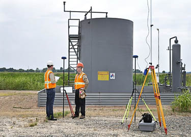
GNSS Surveying. The Global Navigation Satellite System (GNSS) is the foundation for modern surveying. GNSS pulls data not only from the American global positioning service (GPS) but from other entities as well, creating even more accurate results. Historically, surveyors physically canvassed areas to plot coordinates and demarcate boundaries; everything was done manually and on-site. Using GNSS surveying equipment, surveyors can access geographic data points gathered by a network of satellites that rotate around the earth and collect positioning data on an ongoing basis. This switch has dramatically increased surveyors’ productivity and made their surveys much more accurate

High-Tech Data Collectors. In the past, collecting data was one of the most time consuming parts of the surveying process. While manually canvassing an area, surveyors would physically enter their data and sketches, often using a pencil and paper. High-tech field data collectors enable automatic entry of thousands of points of data into an online system. This process has revolutionized the surveying field by significantly reducing the number of people and the time it takes to complete a survey. In addition, automating the field data collection process minimizes errors caused by human entry.

GIS Mapping. Geographic information systems (GIS) are systems that store mapping information and attributes in digital form so that it can be easily accessed and analyzed. For surveyors, using GIS mapping is a powerful tool, because it helps provide a simple, visual context for what would otherwise be complex, spatial datasets. Further, GIS mapping allows data to be easily manipulated using a multitude of variables that can be layered over one another. GIS mapping information is stored in the cloud, so data can be accessed in real-time from the convenience of any device connected to the internet. This feature helps improve communications between surveyors and their clients and gives clients the ability to effectively manage projects on a daily basis from remote locations.

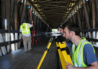
3D Scanning and Modeling.  3D scanning and modeling or “high definition scanning,” as it is sometimes called, is a process that uses advanced lasers to map an area in extremely high detail. Essentially, 3D scanning technologies capture image data points at an incredibly rapid pace to create a precise, almost life-like visual of the project area. Most importantly, 3D scanning technologies precisely map out coordinates to millimeter accuracy, thereby significantly improving the reliability of the survey itself. In turn, clients can make more informed decisions about their projects.

Selecting a surveyor with experience using these technologies can significantly improve a project’s bottom line, especially for Oil & Gas, Clean Energy and other companies, for whom surveying is an integral part of their business. To see how cutting-edge surveying technologies and techniques can help you save time and cut costs, get a no obligation quote today.

Improve Your Construction Project with High Definition Surveying

high definition scanningWhen it comes to commercial and industrial remodeling projects or the expansion of existing infrastructure, it is important to know everything you can about the proposed project – from the ground it sits on to how the new construction will blend with the old. A licensed land surveyor can help you to find out about those issues with high definition surveying and 3D modeling services. The information gained from surveying techniques like these can help to increase a business owner’s confidence in the project, as well as, keep the project on time and on budget.

Why Use 3D Laser Scanning for Construction

High definition scanning gives architects and engineers information that they can use to design projects. This information can help the architects and engineers prepare for emergencies and plan for the future, such as what could happen to a building during a catastrophic flood or earthquake.

The information from the high definition surveying process can then be used to create a 3D model that shows how the project will eventually come together – how it will look and how structurally sound it will be. Additionally, the models can be used in a BIM workspace for extensive projects.

Choosing a land surveying company that provides high definition surveying and 3D modeling can help to speed up a construction project by providing accurate measurements and information about potential hazards that designers can then mitigate. This not only keeps the project on schedule, but also plays a part in keeping the project on budget. Documents created through these scanning services can be transformed into survey documents that help construction crews and engineers to better understand the overall project.

Our experienced team can help you choose the services that will get your project started and keep it moving smoothly. Contact us today to learn more about 3D laser scanning for construction projects, as well as the other services we offer.

Image By: Sira Anamwong

The Benefits of a 3D Laser Scanning Survey

laser-scanningLaser scanning has undeniably revolutionized the field of land surveying. The latest laser scanning technologies enable us to help our clients plan and execute the most efficient projects, and they allow customers to analyze every component of any facility or site. These capabilities help us make better decisions during every step of the project – from the planning stages through completion.

The versatile technology can be applied to a variety of land surveying needs, including change detection, accident reconstruction, 3D drawing creation, pre-project scanning and more.

A 3D Laser Scanning Survey Produces Faster Results, Cuts Field Time

In the past, field surveys could take days or even weeks to complete. Using laser scanning technology, it’s possible for us to complete the same field surveys in just one single day. Laser scanning also enables us to complete fly-throughs, 3D models, detailed animations and maintenance materials in less time than ever before.

A 3D Laser Scanning Survey Reduces Overall Project Costs

The increased speed and accuracy of laser scanning means that our survey team has to complete fewer field visits to collect data. This reduces the overall cost of a project for you.

A 3D Laser Scanning Survey is Highly Accurate

Laser scanning technology produces the most accurate data available. This solid knowledge base helps us help you plan better projects.

A Laser Scanner Survey Is A Versatile Tool

We use laser scanning technologies in many aspects of land surveying. We rely on laser scanning for budgetary and timeline preparation, application implementation, historical preservation, reaching once-impossible areas, change detection, hazard surveying and accident reconstruction. We also use laser scanning to produce detailed topological maps, volumetric calculations, 2D drawings, 3D models and more.

Overall, laser scanning helps us better understand building conditions, and this enables us to make better decisions regarding your projects. To learn more about laser scanner surveying and how it has changed the field of land surveying, contact our team today.

Image By: USACE HQ

How GIS Mapping Services Can Reduce Future Setbacks of A Project

gis mappingEven the best-planned projects can be riddled with costly setbacks.  A well designed GIS serves to dramatically reduce these setbacks by providing the most accurate, up-to-date GIS mapping data to project management at all times.  When utilized across multiple tasks, positions, and departments, our integrated GIS services eliminate the frustration of duplicated efforts and miscommunications at the source of most project setbacks.

What are GIS Mapping Services?

GIS mapping services provide a highly detailed view of your data displayed alongside aerial imagery, hybrid base maps, land use and ownership information, and countless other options masterfully combined to result in a product tailor-made for your exact needs. This product is then updated and edited around the clock to provide you with real-time GIS mapping data at all times for improved decision making in each and every task.

Partnering GIS Mapping With 3D Scanning Services

When used in addition to GIS mapping, 3D Scanning services and visualizations are particularly useful in monitoring structural integrity at all stages of project development.  By utilizing 3D scanning, Project managers can approach their duties with more detailed information than ever before. In doing so, tasks can be assigned more effectively and achieved more efficiently while saving time and funds that were previously wasted during unforeseen setbacks.

These setbacks, delays, and miscommunications can occur for any number of reasons throughout the life of a project.  Our goal is to provide you with industry leading GIS mapping services that will effectively reduce and eliminate these issues while providing constant feedback and support for the long-term success of your project.  For more information on how we can help eliminate costly setbacks in your project, contact us today.

Image By – Jesse Varner

Advancements in Oil and Gas Development with High Definition Scanning

oil and gas developmentFirst used in 1998, laser scanning is now the industry standard for making accurate measurements in even the most complicated environments. This is the future of land surveying, but it is already the norm for us.

How a 3D Laser Scanning Survey Works

A 3D laser scanning survey is appropriate for projects of all sizes, ranging from oil and gas development to historical preservation projects, thanks to advancements in workflows, software and hardware. This technology allows us to collect huge amounts of accurate data at high speeds.

High definition scanning works by moving a narrow beam of laser light across a target. The laser records millions of accurate measurements quickly, then transmits the data to a computer screen. The computer uses this data to create a point cloud that is similar to a 3D model. We also use the technology to scan multiple targets to create virtual walkthroughs, perform containment analysis, draft interactive 3D models and manage inventory.

Producing Highly Accurate Data

The accuracy of data collected with high definition scanning is far superior to that gained by conventional or GPS surveying alone. High definition scanning enables us to reach further afield and collect data in places that were once inaccessible.

Saving Time and Money

After your initial investment, high definition scanning is more affordable than conventional methods. If we need more information about your site, we don’t have to send a survey crew to get it. Instead, we analyze the models and data already collected and extract the information we need. This saves you both money and time.

Better Damage Assessment

We rely on high definition scanning to assess damaged facilities, broken drilling rigs and other problem areas. The technology allows us to quickly and accurately assess the problem and create a viable solution.

If you have never worked with a firm that offers high definition scanning, it is easy to make the switch. You get the added benefits of this technology for the same cost or even less, and get results much faster.   This technological advancement has changed oil and gas development forever. To learn more about how a 3D laser scanning survey can help you, contact us today!