Posts

How New Technology Equals Better Engineering Support

professional land surveyorToday’s civil and construction engineers need access to the right information at the right time in order to support fast, accurate and efficient work. In order to get the visibility they need, engineers depend on engineering support services like land surveying.

In the past, land surveying was a time-consuming process that could seriously delay an engineer’s work. However, there are new technologies in use today that enable engineers to get the visibility and information they need quickly, by significantly speeding up the land surveying process.

Read on to learn more about some of these surveying technologies and to find out how you can put them to work for your organization.

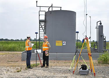
Laser Scanner Surveying

High definition scanning is an innovative technology that allows land surveyors to create detailed representations of a terrain and structures without having to individually visit each point of interest on the job site. Laser scanner surveying helps engineers do their jobs better by providing a more detailed deliverable, and doing it much quicker than a traditional land survey. With terrestrial laser scanning, a process that once took months can now be completed in a matter of a few days, making sure that engineers never have to wait to get the information they need.

High definition scanning, also referred to as LiDAR, works by bouncing laser beams off the terrain and recording a point everywhere the laser hits a surface. Once the area has been scanned, the result is a “point cloud” made up of millions of different points. These millions of points represent a level of detail that engineers could never dream of seeing in the past.
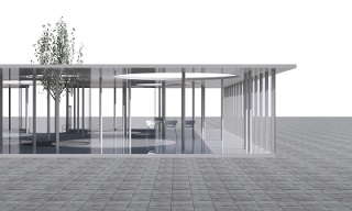
3D Modeling

Once a professional land surveyor has collected data using high definition scanning, they can use those data points to create a survey-grade 3D model of the area. Using this extremely detailed model, engineers are able to get an up-close look at the terrain, without having to waste time by traveling the location themselves.

3D modeling from the point cloud gives engineers a more detailed and accurate look at the terrain and structures they’re going to be working on, and does so in a fraction of the time required to complete a traditional land survey. Also, these models can be used to help inform the survey documents that will drive the entire project forward, ensuring that engineers and all other key stakeholders will always have the information they need right at their fingertips. It’s really no wonder that so many engineers are excited about the possibilities of using 3D modeling as an engineering support tool.
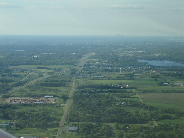
Aerial Mapping

Finally, today’s engineers no longer have to be limited to terrain visibility that is captured from ground level. Using either fixed-wing aircraft, helicopters, or UAV’s, a professional land surveyor has the ability to conduct aerial mapping. This technique can work using a variety of different scanning methods, including the high definition laser scanning described above.

Unlike aerial photography, which merely provides a visual of what the terrain looks like from above, aerial mapping can give engineers a detailed 3D rendering of the terrain, displaying every crack and hole in astonishing detail. Since aircraft have a far greater range of visibility when operating from above than land surveyors do when operating from ground level, aerial mapping can allow quick and efficient scanning of a large area, making it the perfect technology to use on very large engineering projects.

To learn more about new technologies that help engineers work quicker and more effectively,contact Landpoint today.

Image Source : Laura

How Modern Surveying Means Less Time Spent On Site

Oil and Gas ProjectsTechnological advances in land surveying equipment and methods are transforming the industry by streamlining the surveying process and reducing the number of resources needed to complete projects, especially on the ground. Traditionally, field data collection has been a very hands-on process, whereby surveyors expend considerable time and resources on-site to manually map out areas and provide a basic blueprint for clients.

Now, armed with sophisticated technologies, like 3D scanning and modeling, modern GPS surveying tools, GIS mapping, and high-tech data collectors, some land surveyors are transforming the industry. The results – the field data collection process is significantly shortened and clients receive more detailed and accurate results, all the while with fewer resources, especially on site. Ultimately, these outcomes improve clients’ bottom line, expedite the survey life cycle and minimize the risk of costly errors and need for rework.

Which technologies should companies be looking for when it comes to field data collection?

GNSS Surveying. The Global Navigation Satellite System (GNSS) is the foundation for modern surveying. GNSS pulls data not only from the American global positioning service (GPS) but from other entities as well, creating even more accurate results. Historically, surveyors physically canvassed areas to plot coordinates and demarcate boundaries; everything was done manually and on-site. Using GNSS surveying equipment, surveyors can access geographic data points gathered by a network of satellites that rotate around the earth and collect positioning data on an ongoing basis. This switch has dramatically increased surveyors’ productivity and made their surveys much more accurate

High-Tech Data Collectors. In the past, collecting data was one of the most time consuming parts of the surveying process. While manually canvassing an area, surveyors would physically enter their data and sketches, often using a pencil and paper. High-tech field data collectors enable automatic entry of thousands of points of data into an online system. This process has revolutionized the surveying field by significantly reducing the number of people and the time it takes to complete a survey. In addition, automating the field data collection process minimizes errors caused by human entry.

GIS Mapping. Geographic information systems (GIS) are systems that store mapping information and attributes in digital form so that it can be easily accessed and analyzed. For surveyors, using GIS mapping is a powerful tool, because it helps provide a simple, visual context for what would otherwise be complex, spatial datasets. Further, GIS mapping allows data to be easily manipulated using a multitude of variables that can be layered over one another. GIS mapping information is stored in the cloud, so data can be accessed in real-time from the convenience of any device connected to the internet. This feature helps improve communications between surveyors and their clients and gives clients the ability to effectively manage projects on a daily basis from remote locations.

3D Scanning and Modeling.  3D scanning and modeling or “high definition scanning,” as it is sometimes called, is a process that uses advanced lasers to map an area in extremely high detail. Essentially, 3D scanning technologies capture image data points at an incredibly rapid pace to create a precise, almost life-like visual of the project area. Most importantly, 3D scanning technologies precisely map out coordinates to millimeter accuracy, thereby significantly improving the reliability of the survey itself. In turn, clients can make more informed decisions about their projects.

Selecting a surveyor with experience using these technologies can significantly improve a project’s bottom line, especially for Oil & Gas, Clean Energy and other companies, for whom surveying is an integral part of their business. To see how cutting-edge surveying technologies and techniques can help you save time and cut costs, get a no obligation quote today.

Improve Your Construction Project with High Definition Surveying

high definition scanningWhen it comes to commercial and industrial remodeling projects or the expansion of existing infrastructure, it is important to know everything you can about the proposed project – from the ground it sits on to how the new construction will blend with the old. A licensed land surveyor can help you to find out about those issues with high definition surveying and 3D modeling services. The information gained from surveying techniques like these can help to increase a business owner’s confidence in the project, as well as, keep the project on time and on budget.

Why Use 3D Laser Scanning for Construction

High definition scanning gives architects and engineers information that they can use to design projects. This information can help the architects and engineers prepare for emergencies and plan for the future, such as what could happen to a building during a catastrophic flood or earthquake.

The information from the high definition surveying process can then be used to create a 3D model that shows how the project will eventually come together – how it will look and how structurally sound it will be. Additionally, the models can be used in a BIM workspace for extensive projects.

Choosing a land surveying company that provides high definition surveying and 3D modeling can help to speed up a construction project by providing accurate measurements and information about potential hazards that designers can then mitigate. This not only keeps the project on schedule, but also plays a part in keeping the project on budget. Documents created through these scanning services can be transformed into survey documents that help construction crews and engineers to better understand the overall project.

Our experienced team can help you choose the services that will get your project started and keep it moving smoothly. Contact us today to learn more about 3D laser scanning for construction projects, as well as the other services we offer.

Image By: Sira Anamwong