Landpoint
  • Services
    • Land Surveying
    • Engineering Support
    • GIS & Mapping
    • Aerial Data Collection
    • 3D Modeling & Simulations
    • LiDAR – Laser Scanning
  • Markets
    • Oil & Gas
    • Energy
      • Wind Energy
      • Transmission
      • SOLAR LAND SURVEYING
    • Municipal & Federal
    • Industrial & Commercial
    • Residential
  • About Us
    • Company Information
      • Company Overview
      • Locations
      • Awards
      • Clients
    • Work at Landpoint
      • Job Openings
      • Benefits
      • FAQ’s
  • Projects
  • News / Articles
  • Contact Us
  • Menu

Landpoint Selected as Survey Contractor for EPIC Pipeline

You are here: Home / News / Articles / News / Landpoint Selected as Survey Contractor for EPIC Pipeline

Landpoint Selected as Survey Contractor for Permian Basin to Gulf Coast EPIC Pipeline

EPIC Y Grade Services and its subsidiaries passed a major milestone by engaging right of way and survey contractors for construction of the upcoming 650-mile EPIC NGL pipeline. The project is being managed by San Antonio-based EPIC Y Grade Pipeline, LP. The pipeline will allow West Texas and New Mexico based producers to have convenient access to various resources at the export markets in Corpus Christi.

The EPIC pipeline has already started construction at various locations along the route. Additionally, the project will be a major source of multi-year jobs for many Texas-based firms that operate across the state.

Landpoint’s Vice President, Chad Souter, said in a statement earlier this week, “We are excited about the opportunity assist with this game changing infrastructure project. Our people are already working diligently beside the talented professionals at the EPIC portfolio companies to meet its commitments to producers and land-owners alike.” Souter continued by saying “We have helped construct several other pipelines that exist near the proposed route for the EPIC pipeline, and have been impressed with the thoroughness of EPIC representatives as they have transitioned from initial planning to kicking off construction.”

Landpoint will be working closely with the seasoned engineering and right-of-way management teams at EPIC Y Grade Pipeline to assist with the routing and construction of the project. The companies will be applying an assortment of technological innovations, including drones, to help plan, construct, and monitor the various phases of the pipeline as the project progresses.

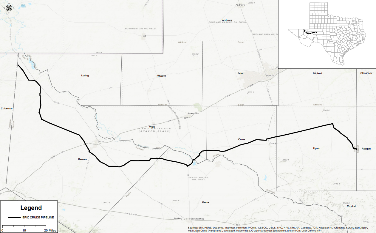
In addition to the EPIC NGL project, the EPIC crude pipeline is a 700-mile oil pipeline that will initially provide 550,000 barrels of oil each day from West Texas as well as South Texas.

For a full press release and information on the EPIC Pipeline project, please visit the EPIC Pipeline, LP website.

Share this:

  • Click to share on LinkedIn (Opens in new window)
  • Click to share on Facebook (Opens in new window)
  • Click to share on Twitter (Opens in new window)

Subscribe

Subscribe to our newsletter and receive monthly updates.

Latest Articles

  • I Connect, We Connect; Life with MSMarch 30, 2022 - 1:08 PM
  • GIS Mapping ServicesWhat Should You Look for In a GIS Mapping Services Provider?March 1, 2022 - 10:05 AM
  • Underground Utility MappingWhich Utilities Need Underground Mapping?February 22, 2022 - 10:20 AM
  • SUE SurveyingThe Importance of SUE Surveying and Underground MappingFebruary 15, 2022 - 10:10 AM
  • Safe Natural Gas Distribution System6 Fundamentals of a Safe Natural Gas Distribution SystemFebruary 8, 2022 - 10:00 AM
  • Pipeline Pig Tracking SurveyThe Role of Surveys in Pipeline Pig Tracking & OperationsDecember 28, 2021 - 9:30 AM
  • Drone Pipeline InspectionsNecessary Components of Safe Pipeline MaintenanceDecember 21, 2021 - 9:00 AM
  • Aerial-LiDAR--What-Are-Your-Options---Blog-4How Does a LiDAR Drone Survey Work?December 14, 2021 - 10:00 AM
  • GIS mapping - Geographic information systemsWhy GIS Is Critical to Utility MappingDecember 7, 2021 - 9:00 AM
  • Oil and Gas Facility, As-Built SurveyIs Natural Gas “Clean Energy”?November 9, 2021 - 8:30 AM
See All Articles

We're here to help.

Call


Client Login

Latest Tweets

Services

Land Surveying
Engineering & Design
GIS & Mapping
Aerial Data Collection
3D Modeling & Simulations
LiDAR Scanning

Recent Articles

  • I Connect, We Connect; Life with MSMarch 30, 2022 - 1:08 PM
  • GIS Mapping ServicesWhat Should You Look for In a GIS Mapping Services Provider?March 1, 2022 - 10:05 AM
  • Underground Utility MappingWhich Utilities Need Underground Mapping?February 22, 2022 - 10:20 AM
  • SUE SurveyingThe Importance of SUE Surveying and Underground MappingFebruary 15, 2022 - 10:10 AM
© Copyright - 2019 Landpoint, LLC
  • Twitter
  • Facebook
  • Mail
  • Linkedin
  • Youtube
Drone Surveying: How Surveyors Overcome the Data Deluge Why Land Survey Companies Are Focusing on Automation
Scroll to top