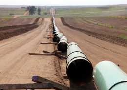
Pipeline Survey
Scope / Requirements
Landpoint was contract to perform boundary surveys for individual tract plats, the preliminary route staking, the final construction staking, and the as-built survey. The preliminary survey consisted of staking and clearing the centerline, right-of-way, and temporary work space while the construction survey consisted of staking the centerline and right-of-way.
Throughout the field staking, our GIS department mapped individual tract plats and updated the daily progress of the route.
Location
This 27 mile trunkline was located in Ouachita and Union County, Arkansas.
Our Role / Services Provided
- Land Surveying
- GIS Mapping
Timeframe
This project was worked on from 2011 to 2014.