A Look at How Oil and Gas Surveying is Becoming Less Expensive

When it comes to oil and gas surveying, a project manager’s main goals should be clear: gather the most accurate data possible while also moving quickly and keeping costs down. On that last point, project managers are now able to benefit from of a variety of new and developing technologies that can support the goal of a more cost-effective land surveying process. In this post, we’ll take a close look at a few of those technologies and what they do to cut costs so that you can be informed when the time comes to shop around for oil and gas surveying services.

Unmanned Aerial Vehicles

Unmanned aerial vehicles (UAVs), also known as drones, are popping up in more and more places these days. There’s a very good reason for this: UAVs have always been very useful in a variety of settings, but until the last few years they have been too expensive for many to consider investing in.

Oil and Gas SurveyingTimes have certainly changed: drone technology has become more sophisticated and available, which in turn translates into lower prices, making UAVs cost-effective in many places they might not have been before.

In addition to rapidly falling startup costs, today’s UAVs are also able to keep operating costs lower than traditional surveying teams could for large scale project. This is in large part due to the fact that UAVs are able to cover large areas quickly, which dramatically cuts the amount of man hours required to complete the oil and gas surveying. In addition, UAVs are able to pass over difficult terrain as the crow flies, with none of the delays that would occur for land-based surveyors.

Centralized Data Storage

Today’s oil and gas surveying services are significantly more detailed and accurate than the surveys of the past. Of course, this is a good thing for project managers, but it also creates an unintended challenge: safely storing massive amounts of data.

Storing all that data can be a very expensive proposition, especially if an organization doesn’t have the IT infrastructure needed to do so. Turning to cloud-based data storage, where a service provider manages the actual storage infrastructure, is a great way to defray startup expenses and keep costs manageable.

In addition, maintaining a centralized repository for data can make an organization more efficient, which will generate cost savings as well. All users can be sure they are pulling from the most recent data, with no potential for time-consuming and productivity-destroying version control issues. In addition, the data can be accessed on any device, including mobile devices, which means users don’t need to use special equipment or leave the work site to get access.

Well Documented and Revisited Locations

Oil and Gas Surveying
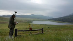
Some of today’s more established land surveyors are extremely familiar with the regions that they service, which can be extremely helpful if you need a land survey. The more knowledgeable a surveyor is with the region, the more efficient they will be when surveying it. Advanced knowledge of an area translates to reduced travel and setup time. It also makes data collection faster as well.

Knowledge of an area can come in two different ways: it may be a region that the surveyor has already visited, or it could be an area in which the surveyor has documentation. Even if they haven’t surveyed the specific area that you are targeting, if they have existing records (or know how to acquire records) of an area, those can be used to streamline the process.

To learn more about the advanced technology solutions Landpoint can offer for oil and gas surveying services, contact our team today.

Landpoint-CTA-Survey

Need Aerial Data Collection? Here are Four Things to Consider

As unmanned aerial vehicles (UAVs) start to become more affordable, they are popping up in a number of industry settings where they might not have been practical before. One instance of this phenomenon can be found in land surveying. Aerial data collection has the potential to revolutionize land surveying for the better, but only if you’re careful to go about doing it the right way.

Before you take the plunge on aerial data collection for your land surveying needs, read this blog post for a closer look at several of the things you should keep in mind in order to help you get the best results. These points will help guide you as you look to hire a provider of aerial data collection for land surveying services.

1. Does the Data Provide Survey-Grade Accuracy?

First and foremost, accuracy is the name of the game when it comes to aerial data collection. There may be some areas of your project where “close enough” is good enough, but the accuracy of your survey data should not be one of them. At the end of the day, if your survey doesn’t provide accuracy that you can use to support informed decision making, then all it really is just a pretty picture.

Make sure you work with a land surveying partner that can demonstrate knowledge and experience with the latest drone mapping techniques. In addition, look for a company that has invested in the most advanced data collection technology available.

aerial data collection

2. Is the Person Flying the UAV A Certified Pilot?

As mentioned earlier in the post, drones are now more affordable than they have ever been. One of the drawbacks of this fact is that it creates a situation where just about everyone feels that they are qualified to operate a drone. However, just because someone has experience using drones as a hobbyist does not mean that you should trust them to conduct your aerial data collection.

For one thing, working with a sUAS certified pilot is the only way to make sure your organization gets complete and accurate data to support its land surveying efforts. In addition, drones in industry are still highly regulated, which means that you may open yourself up to legal trouble if you choose to work with someone who isn’t a sUAS certified pilot.

3. How Is the Data Going To Be Processed And Stored?

What happens to your survey data after it’s first collected is perhaps just as much of a concern as the actual data collection itself. Accurate data is important, but it can’t do you any good unless it’s processed quickly and correctly, provided to you in a useable format, and stored in a way that makes it easy for you to access in the future.

When you meet with potential providers of aerial data collection services, make sure to spend some time discussing their data processing methods. Ideally, they should be able to provide you with processed and useable data within a time window of 24 to 48 hours. Ensuring prompt turnaround for your land surveying data is an important part of ensuring your project proceeds according to schedule.

4. How Advanced Is The Drone Being Used?

aerial data collection

Like everything else in life, the equipment you use for your aerial data collection process matters. Working with a team that has access to the latest in UAV technology is a great way to make sure the data you end up with is accurate, but also gathered quickly and cost effectively.

An example of this can be found in the issue of ground control points. Less advanced UAVs must always set these points in order to ensure accuracy, which can be very time consuming. Newer drones are able to ensure accuracy without them, which leads to a quicker collection process.

To learn more about aerial data collection services, contact the experts at Landpoint today.

landpint-UAV-CTA

How Land Surveyors Can Improve Solar Energy Output

As the energy needs of the world continue to grow, there is more interest in diversifying the way we generate that energy. Renewable energy sources such as wind and solar are generating more buzz all the time, and stand poised to emerge as a very profitable arm of the energy industry in their own right.

In the case of solar, lower prices for solar panels has helped make the idea of utility-grade solar projects a reality. At the same time, solar project managers need to make sure that they organize their work in the most cost-effective manner possible. While the environmental benefits of solar are impossible to deny, it must also make sense from a business perspective before it can really start to catch on in a big way.

In this post, we’ll explore the issue of solar land surveying and how it can help solar project managers get the best results possible.

Properly Positioning Solar Panels

The key to achieving the best possible results from any solar project is to position as many panels as possible into the land available to the project and to make sure those panels are all collecting as much energy as possible.

Many in the solar industry have focused on the concept of orientation, believing that positioning panels in a portrait or landscape orientation can help them pack more panels into a particular length or width of land. However, when one considers the issue of shading—the amount of space that has to be positioned between each panel in order for both to function at full power—orientation usually has little or no effect on how many panels can be positioned in a particular area.

Instead, it makes more sense to focus on how you position your panels, which is where solar land surveying really comes into play. Proper positioning of solar panels includes accounting for things like how many sunny hours a particular area gets on an average day, how elevation and shading effect the ability of panels to function properly, and how much time and energy would need to go into getting the area ready for development. With modern solar land surveying techniques such as laser scanning, organizations can gather detailed data that can be used to create accurate digital models of the area in question. This makes it very easy to make decisions about how solar panels should be positioned in order to create the most powerful, cost-efficient grid possible.

Completing Solar Land Surveying Quickly

Land surveying has the potential to be a tremendous source of value for solar projects, but if it isn’t completed in a timely manner, it can also serve as a bottleneck that delays return on investment for the project.

One of the key factors in establishing utility-grade solar projects is size. The larger a solar project is, the more energy it produces, and the more it’s able to take advantage of economies of scale. Increasing the size of a solar project also has the potential to make solar land surveying take even longer than it would for a more modest project.

This is why taking advantage of modern land surveying techniques such as unmanned aerial vehicles (UAVs) can be so beneficial for solar projects. UAVs, also known as drones, are able to complete their work much faster than traditional land surveying methods. UAVs are able to cover even very large areas in a reasonable amount of time, helping to put solar projects on the fast track to completion and profitability.

To learn more about land surveying techniques for the solar industry, and how they can help provide better results for your solar project, contact Landpoint today.

CTA-Landpoint-Wind

The Advantages of Pairing Land-Based and UAV Surveys

The enthusiasm surrounding unmanned aerial vehicles (UAVs) is high for both hobbyists and industry professionals, so it’s no surprise to see that this enthusiasm is now moving into the world of land surveying. UAV surveys have many benefits for large construction projects: everything from increased speed to greater cost efficiency. Not to mention how UAVs can survey hard to reach areas. However, it’s important to keep in mind that UAVs need cannot completely replace land-based surveying.

Even the most ardent fan of UAV surveys is sure to find certain circumstances where land-based surveying is the preferable option. The key is knowing how to properly balance these two options, in a way that helps you fully take advantage of both, while also avoiding the drawbacks of each. In this post, we’ll explore a few of the reasons why UAV surveys are not right for all situations, and how land-based surveying can fill in those gaps.

Dealing With Weather And Environmental Conditions

First, weather and environmental conditions can make UAV surveys difficult or impossible to perform on some projects. For example, flying UAVs in very high winds can be very difficult. Of course, you can always wait for conditions to improve before trying again, but avoiding delays is one of the key reasons most surveyors use UAVs in the first place. Using land-based surveying can help you stay on schedule and ensure you get the data you need during certain non-flyable weather conditions such as high winds.

In addition, UAVs are currently incapable of carrying any devices that can see through water, vegetation, and other obstacles. If an area you’re surveying has limited visibility that will prevent UAVs from working to their full capacity, you will, of course, need land-based surveyors to take up the slack in those areas.

Ensuring Regulatory Compliance

In the early days of drones, strict federal regulations made large-scale commercial use of drones impractical. Things have certainly loosened up some since then, but there are still certain situations where even using UAV surveys may be against the law. For instance, if your work site is near an airport, a highway, or some other similar piece of infrastructure, you may be limited in where you can legally fly your drone since it could be viewed as a potentially dangerous distraction.

It’s important that you learn the regulations that cover UAV surveys, or that you work with an experienced surveying professional who does. Then, you can make sure to plan your surveying work so that you’re using terrestrial surveys in areas where you would not be allowed to use UAVs.

Areas Requiring Special Levels of Detail

While UAVs have certainly come a long way in terms of their ability to capture data in their surveying work, there still may be situations where UAVs simply aren’t enough on their own. In cases like these, using both land-based surveys and UAV surveys together helps ensure that you get both a very high level of detail, as well as a fast and efficient survey that can be turned around quickly. For instance, UAV-based photogrammetry could be paired with land-based laser scanning, with scanners set up from a wide variety of angles to return more complete results.

In the end, UAVs should be just one of several different tools in your surveying toolbox. While it’s a tool that’s certainly easy to get excited about, that doesn’t mean you should count on it replacing all of the other tools. There will always be circumstances that require a human touch, so you should be ready to address those circumstances when they arise.

Working with a surveying professional can help you get the right mix of UAV and land-based surveys for your project. Contact Landpoint to learn more.

Landpoint-CTA-Survey

High Resolution Aerial Maps: How Detailed Are They?

Many people considering unmanned aerial vehicles (UAVs) for land surveying for the first time are excited about the speed and cost benefits they offer, but are put off exploring the technology further. After all, getting a survey that’s cost effective and delivered quickly doesn’t mean all that much if it doesn’t support a high-quality project.

In this post, we’ll explore the concept of high resolution aerial maps, and show how any concerns one might have about the detail and accuracy of UAV surveys are unfounded. High resolution aerial maps are generally created in one of two ways: through UAV photogrammetry or through UAV laser scanning (LiDAR).

UAV Photogrammetry

Photogrammetry essentially refers to using photographs to create highly detailed maps or 3D models. When attempting to create highly detailed, accurate survey deliverables with UAV photogrammetry, it’s important to keep in mind that the UAV itself is only one small part of the equation. In order to get the best results, you need a high-resolution camera, a suitable drone, and data processing/mapping software.

Since UAV photogrammetry is essentially just taking a large number of pictures from above, one of the best ways to ensure high-quality data is to follow photogrammetry best practices. Collecting quality imagery at the beginning will ensure that your software is able to produce great results.

As the drone flies, the camera will generally overlap individual images by as much as 80-90%. UAVs are capable of accomplishing this level of overlap only because they fly on automated flight paths. No human pilot would ever be able to control a drone in a manner that allows this level of overlapping. This also means that it’s very important for you to get all the images you need on the first flight. Because of overlapping, it will be difficult to integrate photographs taken under different conditions later on.

UAV LiDAR

LiDAR, also known as aerial laser scanning, works by having a scanner bounce millions of light points off the object being scanned and then tracking the trajectory of those laser points as they return to the scanner. The data collected from the scanner is then combined to form a single point cloud, which provides a very detailed representation of the object or terrain being scanned.

Laser scanning has been in use for land surveying purposes for a while now, but the ability to pair it with UAVs opens up new possibilities. For instance, the speed at which the data is collected allows organizations to spend more time analyzing data and using it to draw deeper insights and less time on gathering the data.

As is the case with photogrammetry, you should view the UAV as just the vehicle through which the data is captured. It does not play a defining roll in how detailed and accurate the final product is; instead, pairing it with high-quality LiDAR equipment is the best way to ensure you get the results you’re looking for.

Whether you choose photogrammetry or LiDAR scanning, you should be able to achieve accuracy levels as low as 1-2 cm, depending on the conditions and the equipment you select. This represents accuracy that is as good as or better than land-based surveying, at a small fraction of the price or time required.

To learn more about high resolution aerial maps and how they could benefit your project, contact us at Landpoint today.

CTA-Landpoint-UAV

Why Pipeline Survey Companies Have Been Quick to Adopt UAVs

For pipeline survey companies, the rules of the game have changed. As pipeline right of ways have grown increasingly crowded, and land use and regulatory issues have become more of a concern, pipeline survey companies have had to start taking a new, smarter approach to their work. One way in which they can accomplish this is by adopting the latest innovative technologies. One land surveying technique that can be especially helpful to pipeline survey companies in the new environment they find themselves operating in is unmanned aerial vehicle (UAV) technology, commonly known as drones.

In this post, we’ll take a closer look at why UAVs are such a good fit for pipeline surveying and why so many companies have already begun to adopt them.

1. Cover Long Distances

The first reason that UAVs are such a good fit for pipeline surveying is the fact that pipelines tend to cover very long distances. While the speed at which UAVs complete their surveying work is an asset for any project, the benefits are multiplied for larger projects such as pipelines.

For pipelines that often cover hundreds of miles, traditional surveying methods during initial phases simply aren’t economical. The time required to complete the preliminary surveying process for speculative routes will become a bottleneck, making it take longer to finish the pipeline. UAVs move much faster than these land-based surveys and are capable of removing the bottleneck by surveying even very long pipelines in a reasonable amount of time.

2. Get Into Difficult-To-Reach Areas

Another reason that pipeline surveying is so difficult to complete using traditional surveying methods is the terrain involved. Since pipelines cover such long distances, surveyors may find themselves having to deal with mountains, deserts, swamps, and more. In addition to slowing down the progress of the surveying itself, having to cross this difficult terrain can put surveyors at risk of accident, which presents its own series of complications.

With UAVs, all of the surveying happens above the ground, which means that the surveying work can essentially proceed at the same speed no matter how hard reaching a particular area might be. In addition, surveyors are able to complete their work from a safe location, without putting themselves at risk.

3. An Efficient Way to Capture GIS Data

UAVs can be paired with a variety of different information capturing technologies, but perhaps the most beneficial one as far as pipeline surveying companies are concerned is geographic information systems (GIS).

With GIS, pipeline surveyors can gather the data they need to build detailed computer models of all the possible pipeline routes that are available to the company. After looking at their options and performing simulations, the company can make an informed decision about the ideal routing to act on. If utilized through all development stages, GIS helps ensure a profitable pipeline project with minimal interruptions or complications, and UAVs represent one of the quickest and most cost-efficient methods of gathering the GIS data.

4. Create Detailed and Accurate Surveys

When securing your pipeline right of ways, you may find yourself having to deal with many different private landowners and different political jurisdictions that each have their own unique set of regulations and requirements. In order to get the right of way you need, you need to make sure your company keeps all these different people and agencies happy. An accurate survey can get you off to a great start in this regard by helping you illustrate exactly where your pipeline lays.

By utilizing UAVs, pipeline surveying companies can gather the highly accurate data they need to create preliminary and as-built surveys using high-definition cameras and other advanced data imaging technologies.

To learn more about how UAVs can assist you in your pipeline projects, contact us at Landpoint today.

UAV-Ebook-CTA-2

How Solar Energy Projects Benefit From 3D Laser Scanning Technology

As more and more people continue to show an interest in renewable energy projects, solar has emerged as one option that provides many of the benefits people look for in such technology. However, in addition to being safe and clean, solar energy must also be affordable. This is why running the most efficient, cost-effective solar construction project possible is so important. In this post, we’ll examine how 3D laser scanning technology can play a key role in helping solar energy projects live up to their fullest potential.

What Is 3D Laser Scanning?

In 3D laser scanning, a surveyor uses a scanner to emit a series of lasers toward a building or area of terrain. Once the laser points bounce off the feature being scanned, the scanner tracks their flight paths as they return. Data about these flight paths is then consolidated into a point cloud, which can, in turn, be used to create an extremely detailed 3D model of the scan.

How Can 3D Laser Scanning Technology Benefit Solar Energy Projects?

While there are a variety of industries that could benefit from applying 3D laser scanning practices, there are also some benefits that make 3D laser scanning a good fit for solar projects specifically. A few examples of these benefits include:

  • Supporting solar projects at scale by surveying large areas quickly
  • Identifying proper positioning for solar installations
  • Quick, detailed and accurate results

Surveying Large Areas Quickly

The larger a solar project is, the more effective and cost-efficient it has the potential to be. Larger solar energy projects can take advantage of a number of cost benefits, including economies of scale, repeatable processes, and consolidated permitting.

While the cost benefits of larger solar projects may be clear, the tradeoff is that they require larger areas to be surveyed, which in turn slows down the project and makes it more difficult to begin seeing a return. 3D laser scanning technology empowers solar companies to complete these large surveys in a reasonable amount of time.

Identifying Proper Positioning

Finding the ideal spot for a potential solar installation is another important factor in ensuring a successful deployment. For one, it’s important to select an area that isn’t overly shady, as this shade can interfere with the project’s ability to collect as much energy as possible. In addition, selecting an area when work can begin immediately, without the need to remove trees or brush, can help streamline the project process and accelerate profits.

Building a detailed 3D model based on data gathered from laser scanning can give you the insights you need to make informed decisions regarding the positioning of your solar project.

Quick, Detailed and Accurate Results

For many solar projects, the land surveying portion of the project is looked at as a necessary evil. The project leaders would prefer to finish it as quickly as possible so that they can move forward with actually making a return on their investment. However, it’s important that the results of the surveying also be very detailed and accurate, as failing to meet this standard could interfere with the project’s ability to be as successful as possible.

This is part of what makes 3D laser scanning so ideal for solar projects. Land surveyors can complete their work significantly quicker than they could using traditional surveying methods. At the same time, this speed does not prevent them from turning out high-quality results that can support more informed decision making.

Contact Landpoint to learn more about 3D laser scanning for solar energy projects.

ebook-cta

Satellite Versus UAV Mapping: How Are They Different?

The cornerstone of any successful development is starting out with a good assessment of current site conditions. In order to initiate the assessment that your project requires, it’s essential that you understand the different technology that is available to help you gather the needed information.

This is particularly true when it comes to satellite mapping and unmanned aerial vehicle (UAV) mapping. Of course, these technologies are alike in the fact that they both support mapping functions. However, if you’ve only heard about these two technologies in passing, you may be confused about how they differ from one another and which one might be right for the needs of your project. This post aims to clear up some of this confusion by providing a closer look at both satellite mapping and UAV mapping.

First of all, it’s important to make the distinction that satellite mapping and UAV mapping are not competing technologies. Rather, they are complementary technologies, in the sense that each can do something that the other can’t. This is why it’s so important to understand the differences between the two if you’re going to make an educated decision about which one best meets your needs.

About Satellite Mapping: The Wide Eye In The Sky

It may help to think about different mapping technologies on a spectrum: the further away from the Earth the technology operates, the wider coverage it can provide. However, this wider coverage comes with tradeoffs, in the form of a much lower level of detail and a view that can often be blocked by clouds or other obstacles.

On one end of this spectrum is satellite mapping technology. By definition, satellite mapping technology operates at a plane that is further away from the Earth than any other technology. As a result, satellite mapping provides a level of coverage that is much higher than that offered by any other mapping technology. However, the images gathered using satellite technology are typically very low in resolution, and so may not be useful for projects that require a very high level of detail and accuracy. In addition, the high costs of taking advantage of satellite mapping technology may make it a bad fit for all but the very largest projects.

About UAV Mapping: Filling In The Gap

Several layers down on the spectrum of land surveying technologies is where you will find UAV mapping. As a relatively new surveying technology, UAV mapping fills in an important gap that has existed for decades. This is because UAVs can operate at a much higher altitude than traditional land-based surveying techniques, while of course operating on a much lower level than satellite mapping.

When land surveyors started taking advantage of UAV technology, they opened up a whole new set of possibilities. UAVs provide a level of detail that is comparable to that which can be achieved using land-based surveyors, but is much quicker and safer, and can, therefore, make it easier to begin seeing a return on a project. In addition, UAVs are relatively affordable to use, making them a good fit for many types of projects. Since they are so much closer to the ground than satellites are, they can also provide a much higher level of detail and accuracy.

As this post illustrates, choosing the right land surveying technology for your project is essential to achieving the results you’re looking for. To learn more about how to select the technology that’s right for you, contact us at Landpoint today.

landpoint-ebook-cta

Three Benefits of Using Drones for Pipeline Surveying

Building an oil and gas pipeline project is a major challenge for any organization to undertake. When it comes to building a successful pipeline, the costs and time requirements are high and the margin for error must be minimized. As a result, if organizations hope to complete a successful pipeline development project with no major interruptions and minimal unforeseen costs, it’s essential that they take advantage of the most advanced technologies available to them to collect as much data up front as possible.

One example of a technology that can help organizations experience better results with their pipeline projects is the unmanned aerial vehicle (UAV), commonly known as drones. The benefits of drones for the land surveying portion of a pipeline project are numerous. We will cover three of the most important benefits in this post:

  • Completing large surveys with a high degree of accuracy
  • Turning around survey results quickly
  • Sharing the data with key contractors and stakeholders

3 Benefits of Drones for Pipeline Surveying Projects

Completing Large Surveys With A High Degree Of Accuracy

One of the chief challenges of pipeline projects is the sheer amount of distance they must cover, and nowhere is this challenge felt more than in the land surveying stage of the project. Of course, pipeline projects require a high degree of detail and accuracy, but organizations need a way to ensure that getting this accuracy doesn’t slow down the project too much.

Some UAVs can cover miles of linear coverage per day, meaning that they can fly the large distances required by pipeline projects much faster than traditional surveyors traversing the land. At the same time, UAVs can fly close to the ground while using high-resolution image capturing technology that offers up detail as fine as one centimeter per pixel. UAVs truly offer the best of both worlds when it comes to covering long distances and providing high levels of accuracy.

By bypassing difficult terrain altogether, UAVs allow a land surveyor to gather all of the information they might need without actually having to put people on the ground. Instead, surveyors can operate the UAVs from a position of complete safety. Additionally, the amount of data that is collected is exponentially more than that collected by traditional crews.

Turning Around Survey Results Quickly

Another important goal for land surveyors should be to complete their work as quickly as possible so that the pipeline can begin construction. However, this can’t take place if the results of the land survey require weeks or even months of processing time before they can be used. Working with a team of experienced UAV operators is not just a great way to speed up the actual data collection process; such an operator can also begin processing and analyzing that data immediately after it is captured.

As a result, land surveying results captured by UAVs are often processed and available for use within 24 -48 hours of when they were originally captured. This extremely fast turnaround enables organizations to start building their pipelines quicker, which in turn enables them to start experiencing returns quicker.

Sharing the UAV Data

Collecting massive amounts of data is pointless unless decision makers have a way to access the information easily and extract what they need.

Key divisions/subcontractors that should receive access to UAV data at the earliest possible stages include:

  • Surveyors (internal use)
  • Engineering
  • Environmental
  • Land / Right of Way
  • Project Managers
  • And any other companies (such as construction) who are authorized to view and bid on the upcoming project.

Sharing this data will ensure that everyone is on the same page and that bids are much more accurate since the most recent conditions along the route are available for analysis.

To learn more about the benefits of drones and how they can supplement traditional survey crews, contact Landpoint today.

UAV