Archive for year: 2016
What’s Involved With Construction Staking?
 While a good plan is certainly a requirement for any successful building project, getting the blueprint right is really only part of the battle. At a certain point, you have to transform your plans into reality, and construction staking can play an important role in making that happen. Read this post to learn more about what staking is, how it’s performed, and how it can help contribute to a more successful project. Finally, you’ll learn how the services of an experienced and qualified land surveying partner can help you get the construction staking services you need.
What Is Construction Staking?
Construction staking is the process of taking planned improvements and buildings, and then actually mapping them out on the site where the building will take place. It plays a vital role in helping an organization make the leap from plans and blueprints to actual construction work.
In addition to making sure that construction work is performed accurately according to project designs, construction staking can also help a project manager determine where they might be problems with a project plan. Identifying these problems at the staking phase can help save a lot of time and money for the project later on. Instead of having to wait until actual construction work begins to find out about the issue, the project manager can find out about it early, so that he or she still has time to go back and adjust the building plan accordingly.

The Construction Staking Process
As the name suggests, construction staking involves sticking stakes in the ground to map out proposed improvements. Of course, the whole purpose of staking is to position these stakes in the ground so that they match up with project blueprints with the highest degree of accuracy possible.
When a land surveyor comes in to perform construction staking on a site, the project team will be expected to provide copies of all the approved project plans. Once the surveying team has these plans, they will use them to lay out stakes that identify the exact location and dimensions of all planned improvements. This could include stakes to represent the inner and outer walls of a building, the storm and drainage flow, and concrete features such as driveways, sidewalks, and curbs.
The Different Types of Construction Staking
As mentioned previously, each stake might be used to represent the different elements of the project. Each of these elements has to be accounted for properly within the project plan, so a good land surveyor will know how to represent this on site.
In addition, there are two main varieties of construction staking available to you, and which one you choose is dependent upon on the current status of your project and the actual nature of the work being performed. The first type is rough grade staking. The purpose of this staking is simply to map out proposed improvements in relation to final elevation grade of the site. It is generally used for understanding the rough location and elevation of things like roads, parking lots and building outlines, and would take place before a grading contractor would come in to perform their work.
On the other hand, site layout staking is much more comprehensive and exact in nature. This form of staking is the final placement of the horizontal and vertical location of the proposed improvements. A team would then be able to shift directly to actual construction work once the site layout staking has taken place.
Learn More
To get more information about construction staking or to get started planning your construction project, contact Landpoint today.
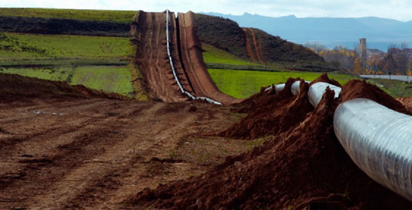
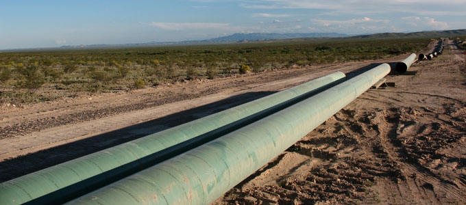
Four Common Problems Encountered in Pipeline Construction
 Building a major oil and gas pipeline is among the most complex projects that any organization can undertake. It is filled with many different potential external bottlenecks that can cause delays, excessive costs, and various other problems. In order to keep a major pipeline construction project on schedule and under budget, you will have to plan ahead, adopt the right technology, and take advantage of assistance from the right kinds of partners, when necessary.
Read this post to learn more about some of the challenges that can arise during the pipeline construction process and what a project manager can do to overcome them.
1. Infrastructure Shortfall
One important concept to be aware of is the fact that most new pipelines are being built in areas that are already served by an existing oil and gas infrastructure. However, in most cases, the pipelines that are already in place are either too old or too small to support the actual oil and gas production capabilities of a particular play. This could be because the capacity of the play was once significantly underestimated or because new drilling technologies have created the potential to reach oil and gas that could not have been reached previously.
Whatever the reason, a pipeline project needs to be able to add on to the current infrastructure, building around existing pipelines and replacing them when necessary.
2. Right of Way Issues
Another major issue when it comes to pipeline construction is the sheer amount of land they cover. Of course, this can be a problem when it comes to securing the right of way to build the pipeline. Major interstate oil and gas pipelines are usually covered by imminent domain, meaning that it would be impossible for local landowners to stop the pipeline from being built.
However, the main pipeline is only one element of the actual project. Wells and smaller lines that feed into the main line are usually located within a single state and therefore require the builder to secure a right of way agreement with each individual landowner. If you don’t plan ahead appropriately, this can be an extremely costly and time-consuming process.
3. Difficult Terrain
Since pipelines typically cover such long distances, there are usually a variety of different terrain challenges that a pipeline construction project must account for. This could include elements like weather (extreme temperatures, rainfall, and major events such as hurricanes and tornados), mountainous terrain (rocky soil that is much more difficult to excavate than ordinary soil), and changes in elevation (difficulty maintaining a steady depth for the pipeline and problems getting equipment to the work site).
Together, all of these issues can cause serious problems for the project that isn’t adequately prepared to deal with them.
4. Geopolitical Issues
The typical pipeline construction project crosses many different political jurisdictions, from municipalities to counties to states. This is primarily an area for concern because each of these individual jurisdictions will have its own unique set of building codes and regulations that you must adhere to in order to build there. This dramatically complicates the building process, as failing to account for even one of these disparate sets of regulations can cause serious delays for the entire project.
In order to make sure that geopolitical issues don’t cause problems with your project, it’s important to start early on getting all the approvals you might need and to work with a partner that understands the unique local regulations in a way that you might not.
The best way to address all these issues is with pipeline routing services from a trusted land surveying partner. To learn more about pipeline routing and how it can help you ensure a smooth pipeline construction project, contact Landpoint today.
Tips for Keeping Oil and Gas Projects on Track
 As a project manager for oil and gas projects, one of your most important priorities should be making sure that everything stays on schedule. After all, these jobs are often very expensive to plan and execute, and the entities funding the work are no doubt going to want to see a return on their investment as soon as possible. Project delays cost a great deal of money, while also pushing back the horizon on how soon the project will start paying dividends.
Fortunately, with the right level of planning and the right technology available to assist you, it’s possible to reduce the chances of a delay. Read this post to learn about some of the main sources of delay in oil and gas projects, and what you can do to overcome them.
1. Miscommunication or bad data
Let’s face it: oil and gas projects are very complex undertakings. When you have a large team of individuals all working on the same project, keeping everybody on the same page is always going to be difficult. With oil and gas projects, where the team can be spread out over long distances, it becomes especially hard. When miscommunication between team members occurs, or when some team members aren’t working from the most recent version of project data, it can cause time-consuming mistakes.
With a cloud-based project management platform, project managers can establish a single central repository for all the project data and communications. The platform can be accessed no matter where a worker may be, including access on mobile devices for field workers. As a result, such a solution can help reduce the potential for miscommunication.
2. Delays in securing environmental approval
While environmental regulations clearly exist for a good reason, it’s impossible to overlook what an inconvenience they can sometimes be for project managers working on oil and gas projects. However, with the right level of planning and awareness, it’s entirely possible for an oil and gas project manager to make sure a project lives up to its environmental responsibilities, while also proceeding according to schedule.
A key concept to keep in mind is that all jurisdictions, including local, state and federal jurisdictions, have their own special environmental requirements. This can cause real problems, especially if you’re building in region that you’re not familiar with. The best way to overcome this is to make sure you start early, and consider working with a land surveying partner who can provide the kind of local knowledge that you may be lacking.
3. Delays in gathering survey data and completing as built surveys
While collecting land surveying data should of course be a part of your project plan, it can sometimes be difficult to make sure you’ve dedicated the correct amount of time to complete this task. There’s no denying the fact that gathering survey data using traditional surveying methods is slow; the only question is how will it affect the rest of the project schedule going forward?
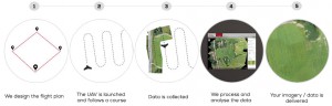
Using aerial data collection performed by unmanned aerial vehicles (UAVs) can help you overcome this issue. UAVs are capable of gathering very large amounts of land data quickly, and their ability to bypass difficult terrain from above means that their work is both faster and more predictable than that performed by land-based surveyors. As a result, you can be sure that you will have all the surveys you need to move forward with your project—on schedule.
To learn more about any of the technologies mentioned in this post or to get started planning your oil and gas project, contact Landpoint today.
How a 3D Model Can Improve Safety in Your Facility
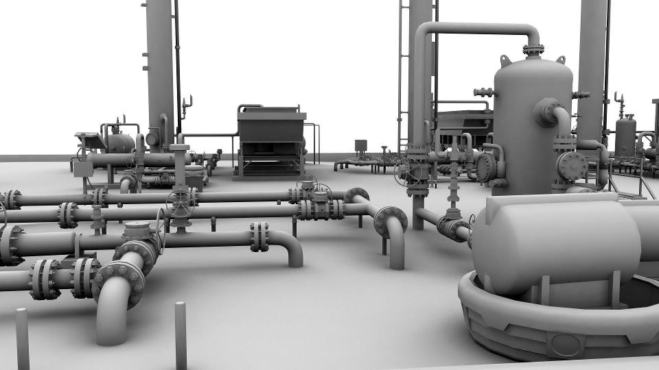 In the oil and gas industry, the safety of project personnel should be among the most important priorities for any project manager. In addition to the obvious human costs of a death or serious injury on the worksite, unsafe work conditions can also lead to project delays and increased costs. Fortunately, there is a way for project managers to control risk, and that is using a 3D model to gain a better visual representation of a site before sending workers into the site.
Whether you’re building a new facility or retrofitting an older one, each oil and gas project has its own unique set of safety concerns. These could include ensuring structural integrity, identifying potentially hazardous work areas, or limiting the amount of work that has to be done in confined spaces. A 3D model can help a project manager address all of these concerns and more by essentially allowing them to know where the risk is without actually having to enter the facility to find it. As a result, a project manager could use a 3D model to create the safest work plan possible for his or her team.
Read on to learn more about how a 3D model can support better safety measures for oil and gas facilities.
1. Keep workers out of harm’s way
The first way a 3D model can help keep workers safe is among the most obvious: by shortening the amount of time that workers actually have to spend in a facility, a 3D model can reduce the amount of time those workers spend exposed to risk. With the greater visibility that a 3D model can provide, a project manager can come up with a plan that allows workers to get in, finish the required work as quickly as possible, and then get back out again.
2. Allow for offsite fabrication methods
Performing “hot work” such as welding inside an oil and gas facility can be especially dangerous for workers. Of course, it is possible to perform the majority of this work offsite, but this capability depends on having the kind of exact measurements that only a 3D model can provide. Once they have these measurements, workers can perform offsite fabrication methods, essentially removing the need for hot work inside the facility. Then, they can simply perform a bolt-up installation once they’re inside the site, resulting in a dramatically safer experience.
3. Create quick and accurate as-built surveys
Having accurate as-built surveys is among the most important methods of identifying and avoiding hazardous conditions inside an oil and gas facility. Using a 3D model to support your as-built survey is a great way to cut out uncertainty and get the kind of fast, accurate as-built survey that’s required to make informed decisions about the best way to complete your project.
4. Take a proactive approach to safety
Any experienced project manager could tell you that the greatest sources of danger within a facility may not always be the most obvious ones. Safety problems on a site tend to emerge slowly over time, which means that waiting until the unsafe conditions become impossible to ignore is not a practical approach. A 3D model can be used to identify problems that workers and project managers most likely would have missed otherwise. With this knowledge, it is possible for project leaders to be proactive and address these issues before they result in safety problems for the project.
To learn more about 3D modeling and how it can help keep workers safe in your oil and gas facility, contact us at Landpoint today.
Getting an As-Built Survey for an Oil and Gas Facility? Consider a BIM

If you’re in the process of building or retrofitting an oil and gas facility, getting an as-built survey is just one of many different things you’ll need to worry about. However, by employing the latest technologies, you can make sure that the process of getting a high-quality as-built survey is simple and efficient. As a result, you’ll have more time and resources to focus on actually completing your project.
In this post, we’ll discuss how building information modeling (BIM), created using 3D laser scanning technology, can help you get the best possible results from your as-built survey.
What Is 3D Laser Scanning and How Does It Apply to BIM?
With 3D laser scanning, a surveyor would set up a series of scanners that will let out thousands of individual laser points. After the laser points bounce off the building in question, their flight path will be tracked as they return to the scanner. Data from individual laser points will be compiled into a point cloud, which can provide a very detailed and accurate representation of the building and its composition.
The point cloud from a laser scan can then be used to create a BIM model, which is a 3D digital representation of the data provided by the scan. Many software platforms can even create the BIM models automatically for certain piping features. Creating BIM models based on data collected by 3D laser scans can help you in a number of ways.
They Help You Complete Projects Faster
Traditional surveying methods can be incredibly time consuming. A surveyor must enter the site and manually take points of the things they wish to survey. The process of assembling these points and formulating them into something that can actually be used to create an as-built survey is extremely slow and can often result in delays to the project itself.
On the other hand, laser scanning is a very quick process. Data is collected and assembled into a BIM model automatically, meaning that your team does not have to wait to get the as-built survey they need.
They Help You Reduce Potential Errors
Individual points are not always reliable when it comes to as-built surveys, as they can be affected by line of sight or GPS errors inside of the facility.
On the other hand, surveying based on laser scanning is both very detailed and accurate. The data gathered by 3D laser scanners will always be the same, no matter what conditions they are acquired in. This, in turn, means that the BIM models you create using laser point clouds will always be accurate. The 3D model you end up with will always be a model of what actually exists. Once you have the BIM, you can use it to make project decisions with confidence.
They Help Reduce Construction Costs
Finally, it’s important to think about how you can keep costs down as you complete your as-built surveys. Traditional surveying methods can lead to inflated costs, because they require more man hours to complete. In addition, the fact that these surveys aren’t always accurate can contribute to expensive rework, while delays in completing these surveys make it harder to achieve a quick return on investment.
By contrast, BIM models based on 3D laser scanning are completed with a high degree of automation, meaning fewer man-hours, reducing the overall cost. Because they are so accurate, a BMI will also help you to reduce the number of costly errors that can pop up during a project, further reducing the cost for oil and gas companies.
3D laser scanning and building information modeling are certainly valuable tools to support your efforts to get a better as-built survey for your oil and gas facility. However, in order to make the most of the benefits offered by these technologies, you need to make sure you’re working with a land surveying partner that knows how to use them. To learn more, contact Landpoint or review one of our project examples to get a look at what we’re capable of.
How New Surveying Technology Keeps Infrastructure Projects on Budget
When it comes to completing major building projects, municipal governments and infrastructure engineering companies face a variety of unique challenges. While these projects have many of the same standards for accuracy, efficiency and safety as any other project, they must also make the most of the limited funding available to them. Since funding for infrastructure projects comes directly from taxpayers, municipal governments are beholden to make the most of that funding.
One way engineers can do this is to keep the land surveying cost down. By working with an experienced land surveying partner, government agencies will be able to take advantage of innovative new technologies that offer the same quality of surveying results at a small fraction of the price. As a result, governments will be empowered to move forward with their building projects with as little wasted funding as possible.
This post will provide a brief overview of some of the technologies that can keep land survey costs down on infrastructure projects.
Unmanned Aerial Vehicles
Unmanned aerial vehicles (UAVs), also known as drones, are increasingly being used in a variety of different industries, and land surveying is certainly no exception.
The cost savings that UAVs represent in land surveying can all be traced back to efficiency. Traditional land surveying methods require surveyors to travel over active areas to complete their work. This can be an excruciatingly slow process. Also, the larger the project area and the more difficult the terrain, the longer the survey will take. In addition to increased man hours, these manual surveying efforts frequently delay the start of actual project work.
By contrast, land surveying conducted using UAVs can cover large areas in a short period of time. In fact, some drones are able to survey 400 acres in a single hour. The data format these surveys can be processed and made available to engineers back in the office quickly. As a result, engineering firms can spend less money on up front and throughout the design phase, helping to ensure that their projects come in at or under budget.
Finally, today’s UAVs can make use of increasingly inexpensive HD cameras and photogrammetry to capture detailed and accurate images from above. This ensures that agencies do not have to sacrifice the quality of their results just to save money. As these cameras become more affordable, the cost of using UAVs to provide land surveying for infrastructure projects will only continue to decrease accordingly.
3D Laser Scanning
3D laser scanning, also known as LiDAR, is another example of a technology that can be used to quickly gather land surveying data. The results of 3D laser scanning can be used to create very detailed models and survey documents.
In 3D laser scanning, a land surveyor sets up a series of scanners that emit thousands of laser points, which would then bounce off the building or terrain that’s being scanned. The flight path and trajectory of the laser beams is tracked as they return to the scanners. The scanners would then assemble the data from the various laser points into a single data cloud, which provides an extremely detailed representation of the object being scanned.
Like unmanned aerial vehicles, 3D laser scanning allows very detailed survey information to be gathered in a small fraction of the time needed to conduct traditional land surveying. This means that using 3D laser scanning can help decrease the labor costs involved with any major building project. In addition, the detailed models laser scanning helps create can increase the accuracy of land surveying work. This supports lower costs by removing the potential for expensive mistakes later on in the project.
With years of experience surveying roads, bridges and public utilities, Landpoint understands the unique challenges infrastructure projects face. We also have the technology needed to overcome those challenges. Contact us today to learn more about our services.