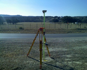
How GIS Mapping Services Can Reduce Future Setbacks of A Project

gis mappingEven the best-planned projects can be riddled with costly setbacks.  A well designed GIS serves to dramatically reduce these setbacks by providing the most accurate, up-to-date GIS mapping data to project management at all times.  When utilized across multiple tasks, positions, and departments, our integrated GIS services eliminate the frustration of duplicated efforts and miscommunications at the source of most project setbacks.

What are GIS Mapping Services?

GIS mapping services provide a highly detailed view of your data displayed alongside aerial imagery, hybrid base maps, land use and ownership information, and countless other options masterfully combined to result in a product tailor-made for your exact needs. This product is then updated and edited around the clock to provide you with real-time GIS mapping data at all times for improved decision making in each and every task.

Partnering GIS Mapping With 3D Scanning Services

When used in addition to GIS mapping, 3D Scanning services and visualizations are particularly useful in monitoring structural integrity at all stages of project development.  By utilizing 3D scanning, Project managers can approach their duties with more detailed information than ever before. In doing so, tasks can be assigned more effectively and achieved more efficiently while saving time and funds that were previously wasted during unforeseen setbacks.

These setbacks, delays, and miscommunications can occur for any number of reasons throughout the life of a project.  Our goal is to provide you with industry leading GIS mapping services that will effectively reduce and eliminate these issues while providing constant feedback and support for the long-term success of your project.  For more information on how we can help eliminate costly setbacks in your project, contact us today.

Image By – Jesse Varner

Need an Alta Land Survey? Get It Made With HD Scanners

land-survey1To assist our clients in designing and executing projects in the most efficient way possible, Landpoint relies on the very latest high definition scanning technologies when creating an ALTA land survey. These innovative technologies help our project managers and outside engineers and architects visualize all the components of any site or facility, and it allows us to make better decisions based on the building conditions.

We utilize high definition scanning to meet a variety of professional land surveying needs, including pre-project scanning, the creation of traditional 2D drawings, change detection, catastrophic event mapping and accident reconstruction, and it is particularly helpful in completing scans for ALTA certification.

Using high definition laser scanning, we can complete a field survey for ALTA certification in just one day. In less time than ever before, we can produce fully interactive 3D models, maintenance materials and detailed animations, including complete fly-trough’s alongside the traditional materials expected from an ALTA land survey.

As a professional land surveying firm, high-def laser scanning benefits our clients in many ways:

Reduced Cost

Using the technology significantly reduces the amount of field visits our team has to make to collect data. This cuts the overall cost to you, resulting in more cost-efficient projects.

Future Planning

The data we collect through high definition laser scanning is not just valuable for your current projects, but can be saved and used for your future projects as well. The accurate, detailed data makes future planning far easier.

Quality Assurance

The data collected using high definition scanning is highly accurate. This ensures that your project will be based on the most solid knowledge of your site.

Speed

High definition laser scanning enables us to collect accurate data more quickly than ever before. Instead of taking weeks or months to complete your project, we can have it finished in just days.

This technology gives project managers insight into their locations that was never available before. The result is better project planning, easier decision making and overall more successful projects.

To learn more about getting an ALTA land survey and how HD laser scanning can benefit you, contact us today!

Image By – survcentex

3-D As-Built Survey in Oil and Gas Development

oil-gas-as-builtUsing the latest 3D high-definition laser scanning equipment and high end 3d modeling software, Landpoint is able to create as-built intelligent models with incredible accuracy. This technology is particularly useful for oil and gas development.

A New Type of As-Built Plan

In 2011, Landpoint created an as-built model of a portion of a gas processing facility in Haughton, Louisiana. We used this innovative technology to create a model that is within ¼ inch accuracy in just ¼ day.  While using only four scanning positions we were able to capture a full 360° detailed view of the facility towers, and the entire project took only 14 days to complete. Before the development of 3D laser scanning, a project of this scope would have taken much longer and resulted in far less accurate data.

With this detailed model, multiple departments can work together to plan future expansions, renovations, or assess the status of current assets already on the ground. This collaboration results in better planned oil and gas development projects and faster results.

Why Getting a 3D As-Built Survey Makes Sense

3D Laser Scanning data and BIM go hand in hand. BIM, or Building Information Modeling, is the technology of the future being used on today’s complex construction projects. It imbeds relevant information into the data of the model such as materials, part sizes, flow rates, tensile strengths, maintenance schedules, life spans, part locations and many more. Scanning is a huge benefit to the BIM process serving as the foundation for renovation, addition or improvement projects or as an effective means to compare As-Built plans to the design model during construction. This significantly reduces costly RFI’s (request for information), mistakes and rework. This ultimately cuts down on the overall time and money spent on your oil and gas development projects.

To learn more about how Landpoint and 3D high-definition laser scanning can bring success to your oil and gas development project, contact us today.

GIS Mapping has Revolutionized Pipeline Surveying

pipeline surveying
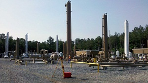
With the ability to manage, analyze, edit, and display data in a multitude of ways, it’s no wonder Geographic Information Systems (GIS) have become an integral part of pipeline surveying and development. Our GIS techniques incorporate first class technology and professional know-how to provide our clients with the very latest pipeline data displayed in real-time at each stage of planning, development, and construction.

What is GIS Used For During Pipeline Surveying?

From the original survey shots for easements and centerlines, to the planned and proposed phases, and all the way up to the finished As-built pipeline, GIS provides the methods to track your data every step of the way. Even multiple re-routes can be kept fully up to date and available to you when time and decision making are of the highest importance. Field crew members, Project Managers, Construction teams, Regulatory Personnel and everyone in between can utilize our GIS services to conduct their tasks more efficiently than ever before.

Pipeline attributes can be very extensive and difficult to organize, but an efficient GIS eliminates this issue. Pipeline size, asset product, grade, wall thickness, length and much more are all made easily available to you both in the office and in the field through our Mobile GIS technology. Pipelines can also be classified and displayed according to their type: Trunkline, Gathering, Lateral, etc. for a clear, concise picture of product flow from the well site to the final destination. From the start of construction to the final regulatory review, our GIS services are aimed to facilitate effectiveness in each and every task for a successful pipeline surveying project.

With an efficient GIS in place, all pipeline data can be housed in a single, well organized location and utilized by multiple positions, departments, and industries each with their own focus and tasks. To learn more on how Landpoint, Inc. GIS mapping can bring success to your pipeline surveying project, contact us today.

Image By: Wessex Archaeology

Solar Energy Plant Development Using GIS

solar energy plant GIS is a powerful tool that makes it easy to collect, store, manipulate, analyze and display accurate information in a geographically organized manner. Using this geographically referenced data, clients can visualize trends, patterns and relationships in the data so they compare the suitability of multiple locations for solar energy plant development.

Using GIS for Renewable Energy Projects

GIS maps begin as simple geographic maps, but they become so much more. We can add an infinite number of datasets to the base map, creating multiple layers of information. Then, we make the maps interactive so you can easily look into specific information for your project, while not losing track of the big picture. GIS plays a critical role in placing solar energy plant projects by allowing planning commissions, policymakers and others to decide which locations are best for developing solar energy with the least amount of impact on the population.

Applications of GIS Data for Solar Projects

This tool also reduces the environmental and social impact of solar energy plant projects. By displaying spatial variables in an easy-to-understand manner a GIS map can help project managers avoid major project complications. GIS can make it more apparent when there are patterns in the data and highlight details that may have been overlooked when seen in a less coordinated fashion.

For example, with the ability to view multiple datasets in just one GIS map, project planners can compare historical ambient temperatures and solar radiation levels in various locations. This allows them to select optimal locations for a solar energy plant’s location.

Through the map, users can calculate the solar radiation available on building rooftops, build digital elevation models and analyze the effect changes in orientation, elevation, and topographical features. Easy-to-use web-based GIS maps take this data and present the logistics of solar energy investment to everyone who needs access. With these web-maps companies can display and share large amounts of data across departments or even between organizations so everyone has a chance to use the data to come up with the best solution.

The Importance of GIS for Solar Projects

This simple yet powerful tool has an intuitive interface that changes the way we view solar energy and opens the door for larger, more widespread projects. Using GIS for renewable energy projects improves the way we deliver and produce energy and supports the development of cleaner, smarter and more eco-friendly methods of energy production. To learn more about how Landpoint and GIS Mapping can bring success to your energy project, contact us today.

Image By: pgegreenenergy

How GIS Mapping Helps With Energy Project Management

GIS mappingAdvancements in GIS mapping help you make more intelligent decisions when it comes to managing your energy projects. GIS organizes geographic data, processes data from a variety of sources, and integrates that information into a map project. Interactive GIS maps allow users to change the nature of the information, scan the map in any direction and zoom in and out to get a more clear picture of the data. This post examines the different GIS applications and how they benefit construction projects.

Increasing Understanding

GIS mapping is a practical system that brings data together from many sources. This facilitates better communication, breaking down the barriers between organizations and increasing understanding. The technology is becoming easier to use and more multidimensional, with better usability and data management.

Changing the Way We View Energy

There are a number of GIS applications that can improve the ways we deliver and produce energy and enhances the way we view our planet’s resources. Using GIS mapping, we can determine the best locations for wind farms, analyze terrain, create maps of the wind, locate the best power resource areas and visualize transmission lines.

GIS mapping can also be used to track the progress of solar installations, calculate the solar energy potential of building rooftops and present the information in a user-friendly format.

Using GIS mapping means analyzing every facet of the design and building process, tracking, maintaining and visualizing all systems and maintaining an enterprise geo-database throughout a building’s life cycle.

Affordable and Accessible

GIS mapping is a rich resource for information and data, but it does not carry a huge price tag. In fact, existing data from land surveying can easily be integrated into a GIS. Clients can access this information through an intuitive, easy-to-use online map.

GIS Applications Set the Standard

Advancements in GIS mapping have enabled us to manage data submissions from multiple parties. This means that not only do we collect field data, but we also establish standards by which other companies collect and submit data. Our centralized system gives our clients a universal location to access data and maps. It also gives clients peace of mind because they won’t have to worry about the consistency and integrity of data coming from other companies.

GIS mapping has proved to be an evolving, flexible technology capable of adapting as the ecosystem around it changes. The technology has embraced these changes, only becoming more valuable and powerful at each step in this evolution.   These are just some of the reasons why GIS mapping is essential to overall project management and completing land surveying projects successfully. To learn more about our GIS mapping capabilities, contact us today!

Advancements in Oil and Gas Development with High Definition Scanning

oil and gas developmentFirst used in 1998, laser scanning is now the industry standard for making accurate measurements in even the most complicated environments. This is the future of land surveying, but it is already the norm for us.

How a 3D Laser Scanning Survey Works

A 3D laser scanning survey is appropriate for projects of all sizes, ranging from oil and gas development to historical preservation projects, thanks to advancements in workflows, software and hardware. This technology allows us to collect huge amounts of accurate data at high speeds.

High definition scanning works by moving a narrow beam of laser light across a target. The laser records millions of accurate measurements quickly, then transmits the data to a computer screen. The computer uses this data to create a point cloud that is similar to a 3D model. We also use the technology to scan multiple targets to create virtual walkthroughs, perform containment analysis, draft interactive 3D models and manage inventory.

Producing Highly Accurate Data

The accuracy of data collected with high definition scanning is far superior to that gained by conventional or GPS surveying alone. High definition scanning enables us to reach further afield and collect data in places that were once inaccessible.

Saving Time and Money

After your initial investment, high definition scanning is more affordable than conventional methods. If we need more information about your site, we don’t have to send a survey crew to get it. Instead, we analyze the models and data already collected and extract the information we need. This saves you both money and time.

Better Damage Assessment

We rely on high definition scanning to assess damaged facilities, broken drilling rigs and other problem areas. The technology allows us to quickly and accurately assess the problem and create a viable solution.

If you have never worked with a firm that offers high definition scanning, it is easy to make the switch. You get the added benefits of this technology for the same cost or even less, and get results much faster.   This technological advancement has changed oil and gas development forever. To learn more about how a 3D laser scanning survey can help you, contact us today!

An Important Checklist for Hiring Environmental Consulting Firms

environmental consulting firmEnvironmental investigations and navigating permitting regulations can be huge projects, but they do not have to lead to huge headaches, especially if you hire the right environmental consulting firm. During your search, remember that site assessments and regulatory services are often a complex process that can take anywhere from a few months to years to complete, and cheaper does not always mean better. Before you make your choice, consider this checklist to find a firm that is a perfect match for your job.

Checklist for Hiring Environmental Consulting Companies

Staff Availability and Experience

Does the firm have the staff to complete your project? Will they have qualified staff members to dedicate to your project? Ask for current resumes of the staff members who will work on your project, and request references for the project manager.

Time Estimates

Can the consulting firm confidently estimate the time required to complete the project? Will there be a tracking tool to determine each and every stage of the project?

Experience

Does the environmental consulting firms have a demonstrated history of successful projects? Does the staff assigned to your project have experience winning ecological approvals for similar projects?

What experience do they have in meeting your specific needs? Do they work with regulatory agencies? Request a list of references and similar projects completed.

Proposal Amounts

Carefully evaluate the firm’s cost proposal. Remember that cheaper is not always better, and in many cases, going with the cheapest firm will create additional unforeseen costs in the future. You get what you pay for, but the best environmental consulting firms are well worth the investment.

Subcontracting

Does the firm subcontract portions of the work? Are the subcontractor activities competitively bid? Check the experience of the subcontractors the firm works with. Environmental consulting companies that use in-house environmental teams are the easiest to work with.

Innovative Approaches

Does the firm resolve issues using a broad spectrum of technologies and resources, including wetland, plant ecology, wildlife, cultural resources and regulatory consulting services? How do they evaluate and eliminate potential risks throughout the process?

Warnings

Beware of firms who take hard-sell approaches, minimize or over-blow potential legal or technical problems, present overly optimistic timelines, have a strong bias for or against certain techniques or are not familiar with applicable regulations. These are all red flags that, if heeded, will save you from paying for expensive mistakes or investing more in the future to improve poor-quality work.

Landpoint’s environmental consulting services exceed all these criteria. Contact us today to learn more about our professional environmental services and how our team can help you navigate the regulatory process with ease.

Image By: US Army Africa

What to Look for in a Land Surveying Company

survey resized 600Choosing the best professional land surveying company up front can save you time, money, worries and potential legal problems down the road. The highly complex and technical work done by land surveying services is the foundation upon which your project will be built, making it imperative that you choose a professional, reputable company. Here are three quick tips to assist in making the right choice.

  1. Sophistication is key.

    Land surveying requires a very specific skill set and complex technologies. Choose a company that uses the most advanced surveying equipment to ensure accuracy. The traditional transit and tape method is surpassed by electronic distance and angle measuring equipment combined with global positioning systems, and these tools result in efficient, accurate and cost-effective land surveys.

    Sophistication goes beyond just the hardware that is used. Select a company that offers a wide range of services, thoughtful integration between services and extensive record management to meet your future needs.

  2. Recommendations and awards matter.

    All land surveyors in the United States must be licensed, but there is still plenty of variation in the level of services provided. A license alone does not guarantee professional land surveying services, just as a driver’s license does not make every driver a pro racer. Choose a reputable land surveying company you can trust by asking other professionals for recommendations. Look for an award-winning company with a proven history of providing accurate services and exceeding customer expectations.

    Land surveying services are a considerable investment, and choosing a company out of the yellow pages or based on an advertisement is not recommended. Protect your investment and get your project started off on the right foot by only choosing a company with outstanding recommendations and a history of award-winning work.

  3. Consider cost, but not too much.

    It may be tempting to go with the cheapest estimate you receive, but the adage “you get what you pay for” rings especially true for the land surveying industry. Cheaper surveys can lead to costly long-term errors, so if you opt to pay less now, you may pay far more later.

    As you consider cost, keep in mind that survey estimates vary according to many factors, including the location, terrain, size of parcel, type of survey, accessibility, time of year, vegetation, level of detail required and other details. To get an accurate estimate, you must meet with a professional surveyor to discuss your specific needs.

    Use this criteria to narrow down your list of options, then meet with each company to discuss what solutions they can provide for you.


    Landpoint, Inc. is a professional land surveying company that excels and prides itself in creating unique solutions and processes for our expanding client base. Contact us today to learn more about our innovative land surveying services.